- News
- City News
- mysuru News
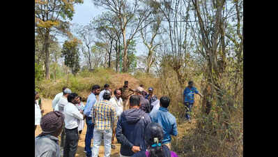
- Boundary dispute over cemetery land in Chikkabettageri resolved
Trending
Boundary dispute over cemetery land in Chikkabettageri resolved
Israel Iran War
Get the latest lifestyle updates on Times of India, along with Women's day wishes, messages and quotes !
End of Article
Follow Us On Social Media

Hot Picks
Top Trending
Tired of too many ads?go ad free now
Trending Stories
In City
Entire Website
- ‘Mental harassment, suicide attempts twice’: What YouTuber UK07 rider Anurag Dobhal said days before crashing Fortuner during livestream on Delhi-Meerut expressway
- Murder in Delhi's Uttam Nagar: MCD demolishes 'illegal portions' of accused's house
- Uttarakhand governor Gurmit Singh’s helicopter makes emergency landing in Srinagar after technical glitch
- Rs 33,500-crore development push for Delhi: PM Narendra Modi to inaugurate key Metro corridors and more; what you need to know
- 'Stabbed her 40 times': 25-year-old engineer kills twin sister, attacks mother after argument over break-up with girlfriend
- Karnataka school horror: Student kills one, injures several in midnight attack at Ballari gurukul
- At over 140 km/h with 80,000 watching live: Watch moment YouTuber UK07 Rider Anurag Dobhal crashes Fortuner on Delhi–Meerut Expressway
- Bengaluru woman ends life after argument with husband over sambar
- 20-year-old woman abducted from street, gang-raped on college campus in Gwalior; trio arrested
- Maharashtra woman throws chilli powder into 3-year-old adopted girl’s eyes
- India crush New Zealand to clinch third T20 World Cup title
- At over 140 km/h with 80,000 watching live: Watch moment YouTuber UK07 Rider Anurag Dobhal crashes Fortuner on Delhi–Meerut Expressway
- US-Israel-Iran War Live Updates: Middle East war day 8: Third US carrier on way as Israel launches 'extensive strikes' on Iran
- Karnataka school horror: Student kills one, injures several in midnight attack at Ballari gurukul
- India win T20 World Cup; full list of tournament champions and runners-up from 2007-2026
- India Wins T20 World Cup: Samson fires 89 as India routs NZ; champions bag ₹27.48cr prize
- IND vs NZ Final Match Timings: What time is India vs New Zealand T20 World Cup match?
- Fresh Food Airlifted Into UAE: LuLu flies 80,000 kg of Indian produce; more imports planned
- Dubai Airport Flight Suspension: Flights halted after aerial interception; partial services resume
- 30-Day Waiver For Indian Refiners: India says oil policy is sovereign; 250 million barrels in reserve
Tired of too many ads?go ad free now


Explore Every Corner
Across The Globe
IND vs NZ HighlightsT20 World Cup Prize MoneyT20 World Cup Winners ListChina Iran relationDubai airportAnurag DobhalIsrael Iran WarAbhishek SharmaIPL 2026India vs New Zealand ScorecardSanju SamsonHighest T20 World Cup Final ScoreT20 World Cup 2026 Closing CeremonyHighest T20 World Cup Final Run ChaseIshan KishanDaren SammyMS DhoniIndian National Cricket TeamSouth Africa Cricket TeamRachin RavindraAlyssa HealyJames AndersonIND vs NZ Match SecuritySunil GavaskarLuLu groupKim Ju AeMurmu-Mamata rowDwarka ExpresswayUttam Nagar murderWhere to Watch Ind vs Nz t20
Hot on the Web
Women's Day WishesHappy Women's Day WishesVijayShah Rukh KhanDhurandhar 2 TrailerAhmedabad Police Traffic advisoryLab Grown GoldBest War Movies On NetflixThe Kerala Story 2War News AnxietyMagnesium DeficiencyWomens's Day MessagesBollywood War MoviesDhurandhar 2 TrailerWomens Day QuotesChiranjeeviAllu ArjunWomen's Day QuotesYami GautamAmitabh BachchanRERA 2.0Maheika SharmaThe Great Indian Kapil Show 4Anurag DobhalDeeksha SethYoung Sherlock ReviewHoroscope TodayThe Bluff Movie ReviewBorder 2 Movie ReviewTu Yaa Main Movie ReviewToday Gold Rate in ChennaiDelhi Weather TodayDelhi AQI TodayMumbai AQI TodayMaharashtra Public Holidays 2026Maruti Brezza Facelift SpiedLab Grown DiamondsMark ZuckerbergSam AltmanSocial Media BanWomen’s Day AI Prompts
Trending Topics
Suryakumar YadavDroupadi MurmuZayed Al NahyanIsraeli Drone StrikeICAI CA Foundation ResultCUET PG Admit CardNOC Vehicle TransferAIIMS Robotic SurgeriesIran vs US Israel warBrett RandellNEET UG 2026 RegistrationNBEMS GPAT Answer Key 2026ICAI CA Intermediate Toppers ListUS Embassy BlastMumbai UniversityBareilly Twin Sister MurderDelhi Meerut Expressway AccidentDelhi Uttam Nagar MurderAbu Dhabi Zayed International AirportDubai travel updateAmritpal SinghJunaid-Nasir murder caseVande Bharat ExpressDelhi Metro corridorsBrooks KoepkaJustin HerbertAlysa LiuMLB opening dayCristiano RonaldoMumbai Indians New IPL JerseyDaylight Saving Time 2026Electric Cars Vs Petrol CarsSam AltmanApple Macbook Air M5Stephen HawkingAnthropic Ceo Dario AmodeiNvidia China DreamMacbook Neo VSMacbook AirOracle LayoffsHow to watch ICC T20 World Cup 2026 in USAHow to watch ICC T20 World Cup 2026 in CanadaHow to watch T20 World Cup online in India
Popular Categories
HeadlinesSports NewsBusiness NewsIndia NewsWorld NewsBollywood NewsHealth+ TipsIndian TV ShowsTechnologyTravelEtimesHealth & FitnessHow to watch T20 World Cup OnlineIndia vs Pakistan MatchAstrologyAutoWeather TodayGold Rate Today DelhiSilver Rate TodayPlatinum Rate TodayIs Bank open todayMarch Bank HolidaysMarch Public HolidaysDeorhiTechnology NewsInternational SportsPublic HolidaysBank HolidaysT20 World Cup Squad IndiaT20 Wprld Cup Squad
Trending Videos
Iranian Missile Barrage Slams Tel Aviv Streets; Explosions, Smoke, Injuries As Israel Hit Again'JUTS WAIT AND...': Iran’s Big Declaration After Trump’s ‘LOSER’ Claim; Signals Deadly Missile Blitz'Iran Can Make 11 Nuclear Bombs In Weeks’: Trump Weighs Ground Strike To Confiscate Uranium'RUSSIA, CHINA…': Putin Aide Issues Stark Warning, Poses Chilling Question To Trump | Iran WarHUGE BLOW To US Army As Iranian Strike On Saudi Base Kills Soldier; Tehran Releases Shock VideoMissile Strike in Saudi Arabia Kills Two as Iran War Escalates, Civilian Area Hit in Al-KharjRoyal Easter Bombshell: Beatrice And Eugenie ‘Advised To Skip’ Service As Family Scandal ExplodesDelhi: Uttam Nagar Murder, Heat Spike, Ram Statue Plan & MoreHezbollah Rockets Pound Northern Israel After Deadly Attack Kills Two Israeli Soldiers Near BorderLocals Protest With Black Flag As CEC Gyanesh Kumar Visits Kolkata To Review Election Preparations
Latest News
Scorpio Horoscope Today, March 09, 2026: Day promises a sense of accomplishment as drive and maturity alignIs LaMelo Ball playing tonight vs the Phoenix Suns? Latest update on the Charlotte Hornets star's injury report (March 8, 2026)Shakira adds THIRD SHOW to India tour; to perform on April 11 following 'unprecedented demand': ReportsFact check: Did Cardi B cheat on Offset with NFL star Stefon Diggs? Viral claim examinedMamata Banerjee flags ‘proof of who shows respect’Fact check: Was a "rock solid" prenup the reason behind Dak Prescott and Sarah Jane Ramos' rumored split?Alysa Liu calls critics hypocrites for attacking Eileen Gu over representing China instead of United States in Olympic debate‘Arrogance will be shattered’: PM Modi slams TMC on President rowCharlotte Hornets vs Phoenix Suns injury report: Who's playing, injured and questionable players, head-to-head records, team stats, and more (March 8, 2026)BJP: Mamata has become 'law unto herself'“She's born a biological man”: Travis Kelce's fiancé Taylor Swift dragged into controversy after psychic’s viral podcast claimsLibra Horoscope Today, March 09, 2026: Moon and Venus support smart accumulation and tidying your spaceExplained: Who is Mojtaba Khamenei? 5 things to know about rise of secretive son from shadow power to Iran's new supreme leader after Khamenei’s killingAlia Bhatt shows off daughter Raha Kapoor and 'Papa' Ranbir Kapoor's adorable Women's Day cardLivvy Dunne reveals secret acting lessons after LSU gymnastics journey as influencer plans new Hollywood career after LSU gymnasticsIs Giannis Antetokounmpo playing tonight vs the Orlando Magic? Latest update on the Milwaukee Bucks star's injury report (March 8, 2026)Travis Kelce’s strategic move involving Blake Lively and Ryan Reynolds raises eyebrows ahead of his wedding to Taylor SwiftWho is Mojtaba Khamenei, the new Iranian Supreme Leader facing US and Israel
Copyright © 2026 Bennett, Coleman & Co. Ltd. All rights reserved. For reprint rights: Times Syndication Service