- News
- City News
- gurgaon News
- 137 ponds in Gurgaon’s green belts to help check flooding during rains
Trending
This story is from September 25, 2021
137 ponds in Gurgaon’s green belts to help check flooding during rains
Officials said the decision was taken during a meeting of the GMDA’s residents advisory council on Friday, and directions were given to agencies, including the Municipal Corporation of Gurgaon (MCG), to begin work.

Speaking to TOI, a senior GMDA official said, “Waterlogging in the city and the use of green belts to resolve the problem was discussed extensively in Friday’s meeting. It was decided that Gurgaon should be made completely free of waterlogging, and ponds in green belts will be used to help achieve this goal. The main motive is that rainwater should not flow onto roads.”
There are several ponds in Gurgaon’s green belts that are very old but have dried out over the years and are lying neglected, the official added. “A total of 137 such ponds have been identified by GMDA, and a decision has been made to develop them so that rainwater gets diverted to ponds instead of inundating roads. The ponds will also act as catchment areas. This will spare commuters and residents several problems that crop up every monsoon. Once these ponds are ready, rainwater will flow directly into them and the waterlogging issue will be resolved to some extent,” the official further said.
GMDA officials said to prevent flooding this time, they built three check dams along creeks in the Aravalis near Golf Course Road over the past year, which led to rainwater being diverted to the forest area before it could reach the stretch. Several native species were also planted around these creeks so that the soil doesn’t become loose and the embankments don’t give way.
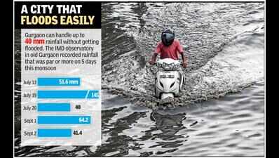
On August 19 last year, almost 120mm of rainfall had left several parts of the city inundated, including parts of Golf Course Road. The underpass in DLF-1 was completely submerged as a result. It had taken DLF, which manages the underpass, two days to finally pump out all the water and reopen it for traffic.
The inundation of Golf Course Road had taken government bodies completely by surprise, as the stretch had not appeared anywhere in the critical points list that they had prepared. DLF had blamed the city’s “insufficient drainage infrastructure”.

About the Author
Sakshi DayalEnd of Article
FOLLOW US ON SOCIAL MEDIA


Photostories
Hot Picks
TOP TRENDING
Popular Categories
Hot on the Web
Top Trends
Liam PayneNayab Singh SainiIND vs NZ Live ScoreRohit SharmaIndian Team Lowest ScoreUGC NET ResultInfosys Q2 ResultHaryana Cabinet Ministers ListJustin TrudeauFlights Bomb ThreatJharkhand Election ScheduleBrandon McmanusMaharashtra Election 2024US Presidential Election 2024Maharashtra Election ScheduleJharkhand Election ScheduleLive Cricket Score
Trending Topics
Diwali WishesDhanteras 2024Fake PaneerLiam PayneVettaiyan CollectionVicky Vidya Ka Woh Wala Video CollectionLawrence BishnoiJigra OTT ReleaseCow GheeBigg Boss 18Salman KhanShraddha KapoorRenukaswamys WifeSharad Purnima Moonrise TimeSwatantrya Veer SavarkarSharad Purnima 2024Top Load Washing MachinesBest Premium LaptopsIntel LayoffsWordle Answer
Living and entertainment
Latest News
Injury scare for Team India as Rishabh Pant hobbles off the fieldHappy Dhanteras 2023: Images, Quotes, Wishes, Messages, Cards, Greetings, Pictures and GIFsDelhi BJP decides to go local, focus on roads, water, sanitation in election campaignLiam Payne's final meeting with Argentina fans at hotel goes viral; boy says 'You saved my life' - WATCHDA hike calculator: Dearness allowance & relief hiked by 3% - here’s how much extra salary, pension central government staff & pensioners will getKartikay Agarwal: Decoding how he is playing a role in the AI revolution and entrepreneurship renaissanceRaima Sen on playing iconic Suchitra Sen: It would be an honourTrending couple tattoo ideasBigg Boss Tamil 8 Preview: Emotional turmoil as housemates tease Dharsha Gupta over her cookingSalman Khan’s security beefed up after Baba Siddique’s murder: Arbaaz reacts, Vivek Oberoi's old video goes viral, and all that happenedLong-distance Karwa Chauth? Here’s how to celebrate when you are miles away from your partnerKamala avoiding any interviews that won't post-edit her answers: MuskCol CK Nayudu Trophy Cricket: Himachal Pradesh escape with a draw against RajasthanTony Khan hails Shelton Benjamin’s AEW in-ring debut as he sets up clash with Swerve StricklandKartik Maas 2024 Start and End Date: Time, Puja Rituals and Significance7 deadliest reptiles in the world from venomous snakes to turtlesDesi ghee and olive oil mixture: Can it help regrow hair?Bhopal to witness power cuts today; check details here
Copyright © 2024 Bennett, Coleman & Co. Ltd. All rights reserved. For reprint rights: Times Syndication Service