- News
- City News
- dehradun News
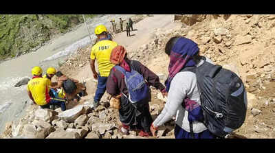
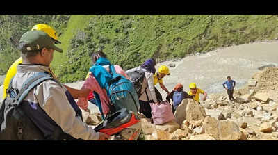
- ‘Erratic monsoon, old fault lines surge landslides in Garhwal Himalayas’
Trending
‘Erratic monsoon, old fault lines surge landslides in Garhwal Himalayas’


About the AuthorGaurav Talwar
End of Article
Follow Us On Social Media
Hot Picks
Top Trending
Tired of too many ads?go ad free now
Trending Stories
In City
Entire Website
- Maharashtra Elections 2026 Live Updates: Mumbai police tighten security ahead of BMC polls; 1,700 candidates in race for 227 seats
- Air India Delhi-New York flight engine damaged after container sucked in at IGI airport; watch
- Not your ordinary 'Mallika': Inside the mind of India’s first female serial killer; how she murdered women in Bengaluru
- Cab fare soars to Rs 600, Dwarka Expressway commuters seek buses linking Gurgaon to metro stations
- Maharashtra civic polls: Erasing indelible ink won’t allow re-voting, says state election panel; SEC warns voters
- ‘Forced to pay for bullets that killed their kids': Iranians in India recount Tehran horror
- Cash Allegedly Distributed For Votes: Residents report envelopes with ₹500 notes; van full of cash seen
- 1,129 farmer suicides in Marathwada in 2025
- Delhi-NCR shivers under fog blanket: Cold wave continues, IMD issues 'yellow' alert; flight ops impacted
- Mumbai BMC elections 2026: What’s open and closed on polling day- check all details
- MI vs UPW, WPL: Harleen Deol guides UP Warriorz to first victory of the season
- “I want to go home”: Tyreek Hill’s cryptic tweet sparks speculation among Falcons and Chiefs fans
- Dodgers pitcher Clayton Kershaw confirms final World Baseball Classic appearance for Team USA
- Sherrone Moore’s termination letter cites violations of morality, public decency, and supervisor-employee relationships
- BMC election result 2026: When and where to watch live counting - all you need to know
- Ricky Stenhouse Jr. takes on new challenge with NASCAR Truck Series start at Daytona
- Memphis Grizzlies vs Orlando Magic (1-15-2026) game preview: When and where to watch, expected lineup, injury report, prediction, and more
- John Harbaugh lands huge Giants contract as New York bets big on Super Bowl winning coach
- ‘Felt so incredibly loved’: Patrick Mahomes and Brittany caught Randi completely off guard with this special family moment
- RSMSSB Rajasthan Grade 4 result 2025 to be released tomorrow, confirms board chairman Alok Raj
Tired of too many ads?go ad free now


Explore Every Corner
Across The Globe
Maharashtra BMC Elections 2026Candace OwensClayton KershawMemphis Grizzlies vs Orlando MagicPatrick MahomesSherrone Moore Termination LetterKai CenatTyreek Hill TweetJa Morant MansionNHL Trade RumorsKobe Bryant WifeMLB Trade RumorsKirk CousinsStephen Curry FatherBudget 2026Iran ProtestsBank holiday todayCheck Voting BoothIBPS RRB Clerk Prelims ResultStock market holidayIBPS PO SO ResultBMC Election 2026Memphis Grizzlies vs Orlando MagicVegas Golden KnightsWinter Olympics 2026Phil Taylor Net WorthKatie LedeckyMitch MarnerWPL 2026 ScheduleT20 World Cup 2026 Schedule
Hot on the Web
Indian RiverKhushi MukherjeeAkshaye KhannaBorder 2 TrailerHappy Patel First ReviewJana NayaganDhurandharBhuvan BamCountries With Most VegetariansBaby Boy NamesSteamed Breakfast DishesLaughter Chefs Season 3Parasakthi CollectionSnake Plant BenefitsBigg Boss Marathi Contestants ListDhanushDisha PataniHrithik RoshanBhuvan BamPlatoJana Nayagan Movie HearingThe Raja Saab Box Office CollectionMary KomJana NayaganAnaganaga Twitter ReviewDhurandhar Movie CollectionSeema Bansal StoryMana ShankaraVaraprasad Garu CollectionDhurandhar Movie ReviewDev AnandWilliam ShakespeareWorld Most Famous Winter FestivalWorld Largest Beaver DamWorld's Only Floating National ParkTiny Ancient CreatureLongest Venomous King CobraNorthern LightsRichest Men In The WorldApple iPhone 17Veg LaphingFirst Medical Evacuation From ISS
Trending Topics
Drake MayePittsburgh PenguinsIslam MakhachevJa MorantTom BradySLAT 2026 ResultRSMSSB Rajasthan Grade 4 Result 2025BMC Election 2026US Aircraft ReturnUS Missile CrisisBMC Poll PredictionsIran UnrestKevin DurantDelhi weatherDelih-NCR fogMaharashtra Elections 2026Haryana rapeBank holiday todayStock Market HolidayIndia vs New ZealandUtah Jazz vs Chicago BullsG7 EconomyWhite House MeetingUS Immigration Policy 2026US Freezes Visa ProcessingCanada Travel BanMohammad RizwanAdin Ross ControversyGold price predictionCardi BTJ WattJensen HuangNyt ConnectionsBGMI UpdateBattlefield 6 Season 2Jeff BezosMira MuratiBill GatesElon MuskMark ZuckerbergVisa Free Countries For IndianWordle Today
Popular Categories
HeadlinesSports NewsBusiness NewsIndia NewsWorld NewsBollywood NewsHealth+ TipsIndian TV ShowsTechnologyTravelEtimesHealth & FitnessDelhi Gold Rate TodayChinese Horoscope PredictionsMarketsAstrologyWeather TodayPlatinum Rate TodaySilver Rate TodayGold Rate TodayIs Bank open todayIs Bank Open TomorrowBank Holidays January 2026Public Holidays January 2026DeorhiNFL ScheduleTechnology NewsInternational SportsPublic HolidaysBank Holidays
Trending Videos
Key NATO Leader Warns Military Alliance As Trump Presses Greenland ControlSwiss New Year Fire Horror: Waitress Allegedly FORCED To Wear Helmet Before Deadly Blaze | WATCHHuge Strike Near Venezuela! US Forces Capture 6th Oil Tanker After Defying Trump's OrderTrump Floats Insurrection Act As Minneapolis Protests Erupt After ICE ShootingsTrump Aide SNAPS At Saudi, Qatar & Oman For Claiming To Pull US Back From Attack On Iran's KhameneiSalman Khan Casts Vote In BMC Polls In Mumbai’s BandraShabana Azmi Casts Vote In Mumbai BMC Polls, Urges Citizens To Exercise RightRanbir Kapoor Casts Vote In Mumbai BMC Polls, Shows Inked FingerBJP MP Sudhanshu Trivedi Warns Against Left Ideologies, Launches Tarun Vijay’S Book Mantra-Viplav"India’s Startups Thrive on Stable Policies" Zerodha Founder Nikhil KamathIran Protest Horror: BBC Comedian Says Regime Killed Friend’s Brother, Demanded £3,700 | Watch‘Attempted To Flee’: Coast Guard Intercepts Pakistani Fishing Vessel In Arabian SeaFrom Denial To Confession: Lashkar Commander Confirms Op Sindoor Hit, Lays Bare Pak Terror StateZelensky's Days Numbered? Putin's 'Ukraine Running Out Of Time' ULTIMATUM As Trump Blames KyivPutin’s Men Encircle Ukrainian Troops, ‘Bloodbath’ On Front; Russia Claims Control Over 300 Sq KmsHere's Why Timothy Busfield's 'No Choice' 20-Hour Drive Before Surrender Is Raising EyebrowsNoida Headlines Today — The Biggest Updates You Need to Know.Krishna Bhakti Explained: Nityanand Charandas on Devotion, Love, and the Path of Dharma
Latest News
Guwahati to get high-performance sports centreAssam aims to generate 3,500 MW of solar power by 2030: HimantaOnline pension application module launchedAamsu ex-chief quits Cong 3 days after joining partyCyber crooks dupe man of Rs 12.77 lakhIndia gets playoff spots in Asian competitionsSivasagar DC inspects progress of Rang Ghar beautification projectEastern W Khasi Hills bans fish ‘illegally imported’ from BangladeshCoke Studio Bharat Turns City Into a Live Concert as Indie Music Blends With Folk RootsHajo hosts Manikut Utsav, promoting interfaith harmonyIDP resettlement only where stability assured: ManipurTinsukia issues ‘No Helmet, No Fuel’ policy to curb accidents4-yr-old falls into under-construction JJM tank, drowns10k artists to perform Bagurumba before PM in Guwahati on Jan 17Google launches Google Market Access Program for Indian startupsSambalpur, Cuttack dists report most CKD cases in stateWomen's Asian Cup: Crispin, support staff to continue with national teamGarima urges Centre & state to monitor Coroner’s inquiry in S’pore
Copyright © 2026 Bennett, Coleman & Co. Ltd. All rights reserved. For reprint rights: Times Syndication Service