

- Iran secretly bought Chinese satellite tech via UAE — then struck Abu Dhabi: Report
- 'Whatever it takes': Canadian citizen Shaan Hundal keen on following in Ryan Williams' footsteps
- ‘Girls are a burden’: Delhi father kills 10-month-old, dumps body in septic tank, then cries kidnapping
- Gujarat woman shot dead in US store; chilling CCTV footage emerges
 Loading..

City
 AIMIM Helped BJP? Saffron Party Secures Shocking Victory In Delhi's Muslim-Dominated Seat04:34
- Delhi Hands Kejriwal A Humiliating Defeat; BJP Crushes AAP, Top Guns Humbled | Watch06:15
- Delhi Debacle: Big Fight In INDIA Bloc; Cong Jibes AAP, Omar Slams Allies | Watch04:26
- Delhi Results: BJP 'Wipes Out' AAP; Big Comeback After 27 Yrs | Kejriwal's Fate Hangs In Balance03:39





EC orders FIR against Rahul Gandhi for TV interview on Gujarat poll eve
File that could solve Bose’s death mystery ‘closed for 100 years’
Somnath temple visit: Rahul Gandhi listed as 'non-Hindu'
Woman passenger, Air India duty manager slap each other at Delhi IGI airport
Saudi prince vows new Islamic alliance 'will wipe out terrorists from earth'
Over 200 worshippers killed at Egypt mosque in deadliest terror attack
PIC: Adira's birth announcement cradle filled with goodies!
Rumoured 'Dabangg 3' actress leaks topless pics for publicity?
PIC: AbRam kissed by two girls!
PIC: Varun Dhawan gearing up for underwater stunts
PICS: Deepika Padukone back on ‘xXx’ sets
What made Hrithik run behind his son Hrehaan?
Purify your home with these houseplants
The easiest Shahi Paneer recipe!
Serve your drink in the right glass
Kangana unhappy with Hrithik for dragging Rangoli into their battle?
PIC: Arpita Khan's maternity photoshoot
Sonam Kapoor speaks about her alleged love affair
Hafiz Saeed's release is an attempt by Pak to 'mainstream' UN-proscribed terrorists: India
As the old order changeth, India's Bhandari fills up last vacancy at ICJ
Look at your career before commenting on Dhoni: Shastri
How to look good without make-up
7 mistakes people regret making in bed
Do you know about this new sexual orientation?
Azad's gift for Aamir will melt your hearts!
Aamir Khan - Flashback to the Future!
Sanjay Dutt and Salman Khan end their friendship?
5 authors who have been accused of plagiarism
Budget Cooling: Affordable ways to stay chill this summer
From Alia Bhatt to Sridevi: Who wore what at Justin Bieber’s concert






















Cyclone Fengal Highlights: Puducherry declares holiday for schools, colleges amid heavy rain
IMD nowcast till 10pm
Moderate intensity rainfall with moderate thunderstorms and lightning likely at isolated places over Chennai, Tiruvallur, Kancheepuram, Chengalpet, Cuddalore, Villupuram, Kallakurichi districts of Tamil Nadu and Puducherry
Moderate intensity rainfall with light thunderstorms and lightning likely at isolated places over Chennai, Tiruvallur, Kancheepuram, Chengalpet, Cuddalore, Villupuram, Kallakurichi districts of Tamil Nadu and Puducherry
Chennai rains: IMD forecast for Saturday
For November 30, the IMD has forecast isolated heavy to very heavy rain with extremely heavy rain at one or two places in Chennai, Tiruvallur, Chengalpattu, Kancheepuram, Villuppuram, Kallakurichi, Cuddalore districts and Puducherry. Also, heavy to very heavy rain is likely to occur at isolated places over Ranipet, Tiruvannamalai, Vellore, Perambalur, Ariyalur, Thanjavur, Tiruvarur, Mayiladuthurai, Nagapattinam districts and Karaikal area.
Cyclone Fengal set to make landfall on Saturday, red alerts issued in Tamil Nadu Andhra Pradesh
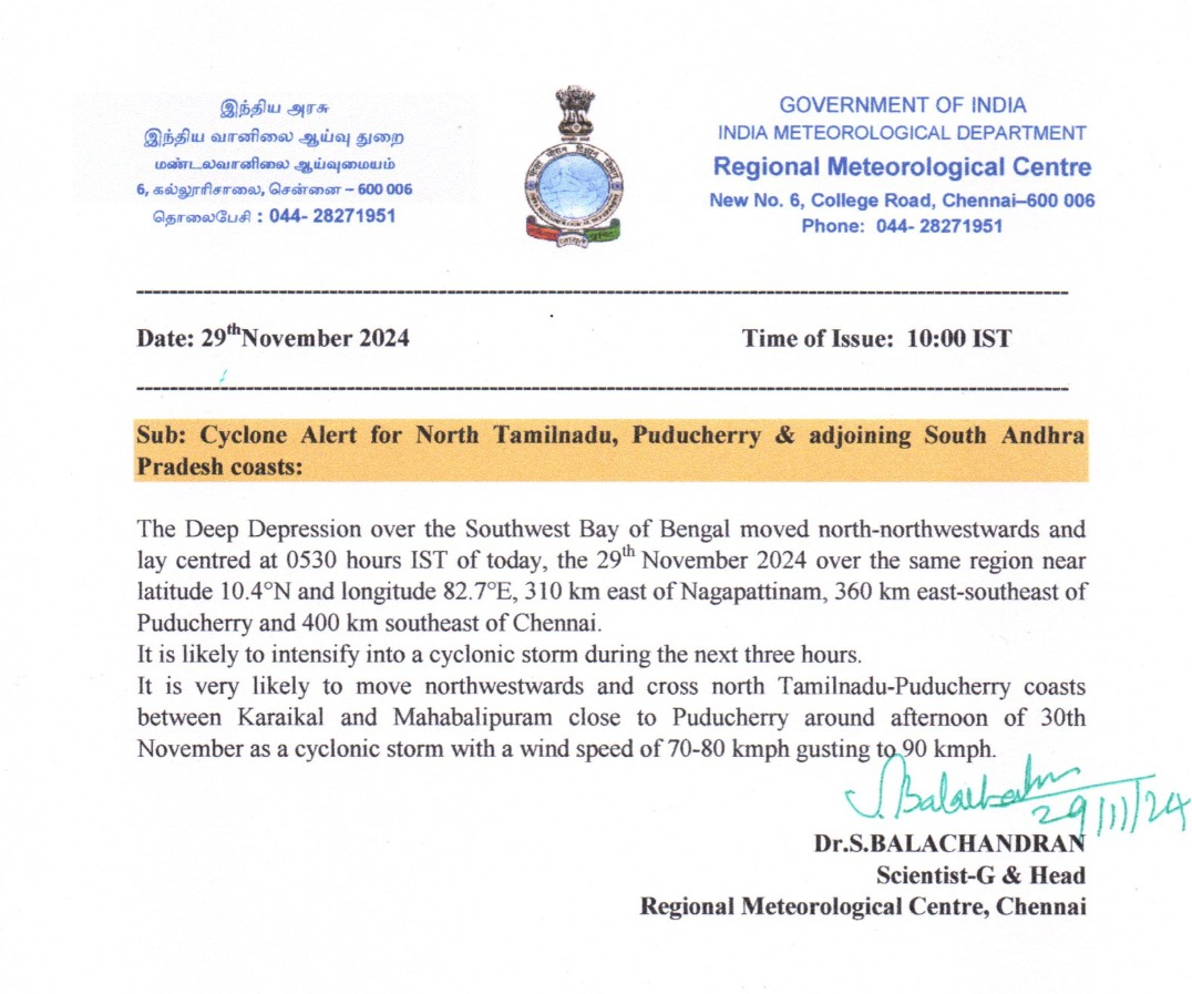
Cyclone Fengal is set to make landfall between Karaikal and Mamallapuram on the north Tamil Nadu-Puducherry coast on the evening of November 30, with wind speeds of 70-80 kmph gusting to 90 kmph. The IMD has issued a red alert for Chittoor, Nellore, Tirupati, and Annamayya districts in Andhra Pradesh due to expected extremely heavy rainfall, while Prakasam and YSR Kadapa districts are under an orange alert. Coastal Tamil Nadu and Andhra Pradesh are also expected to experience heavy rainfall starting November 29, with interior Tamil Nadu likely to see significant rain on November 30. Fishermen are warned to avoid the southwest Bay of Bengal due to rough seas.
Visakhapatnam Cyclone Warning Centre director issues update on cyclone Fengal
On Cyclone Fengal, Director, Visakhapatnam Cyclone Warning Centre, Srinuvas says, "...It is likely to move in the northwest direction and intensify into a cyclonic storm. In the next six hours, it is likely to move in the northwest direction towards and cross North Tamil Nadu and the Puducherry coast...Cyclone alert has been issued for the adjoining districts of Tamil Nadu...We have given an extremely heavy rainfall warning for the districts of Nellore, Tirupati and Chittoor for the next 24 hours..."
Chennai Rain Live: IMD head gives update on cyclone formation
On Cyclone Fengal, IMD Head Ananda Das says, "As far as the impact of the cyclone is concerned, slight rainfall has started. It is still 300-350 km away from the coastline of Tamil Nadu. The landfall is expected tomorrow evening on the coast of Tamil Nadu. The speed of wind would be 70-80 kmph gusting to 90kmph. It has turned into a cyclonic storm... Coastal districts of North Tamil Nadu and South Andhra Pradesh will receive heavy rainfall... On November 30, there will be heavy rainfall in the interior area of Tamil Nadu... Red alert has been issued in view of heavy rainfall..."
Cyclone Fengal forms over the Bay
The Cyclonic Storm Fengal developed from a Deep Depression over Southwest Bay of Bengal, advancing north-northwestwards at 13kmph over six hours. As of 2:30pm, it was positioned in the same region, approximately 310 km north-northeast of Trincomalee, 260 km east of Nagappattinam, 270 km east-southeast of Puducherry and 300 km southeast of Chennai.
The storm is expected to proceed west-northwestwards, making landfall between Karaikal and Mahabalipuram, near Puducherry along the north Tamil Nadu-Puducherry coastline. The crossing is anticipated during November 30 afternoon, with the cyclone maintaining wind speeds of 70-80 kmph and gusts reaching up to 90 kmph.
Chennai Rain Live: Deep depression in Bay of Bengal Likely to intensify into Cyclonic Storm within next 6 hours
"The deep depression in the southwest Bay of Bengal is still classified as a deep depression but is intensifying. We expect it to develop into a cyclonic storm within the next six hours," says Ananda Kumar Das, Scientist, IMD, giving an update on weather conditions in south India in view of Cyclone Fengal.
Chennai Rain Live: IMD Nowcast till 4pm
Moderate intensity rainfall with thunderstorms and lightning at a few places over Chennai, Tiruvallur, Kancheepuram and Chengelpet districts
Light to moderate intensity rainfall with thunderstorms and lightning at isolated places over Ranipet, Villupuram, Cuddalore, Mayiladuthurai, Nagapattinam, Thiruvarur, Thanjavur, Pudukottai, Sivaganga, Virudhunagar, Ramanathapuram, Madurai and Dindigual districts and Puducherry and Karaikal area.
Chennai Rain Live: Heavy rain lashes parts of city
As per IMD, Deep Depression over Southwest Bay of Bengal is likely to move northwestwards and intensify into a cyclonic storm during the next 06 hours. Thereafter, it is likely to continue to move northwestwards and cross north Tamil Nadu-Puducherry coasts between Karaikal and Mahabalipuram close to Puducherry as a cyclonic storm with a wind speed of 70-80 kmph gusting to 90 kmph during afternoon 30th November.
Chennai Rain Live: Chennai experiences high tides, gusty winds
Chennai is witnessing high tides and gusty winds due to the deep depression over the Bay of Bengal.
The India Meteorological Department (IMD) has reported that the system, currently moving northwestwards, is likely to cross the north Tamil Nadu-Puducherry coasts between Karaikal and Mahabalipuram, near Puducherry, by the morning of November 30. It is expected to weaken into a depression during landfall, with wind speeds of 45-55 km/h, gusting up to 65 km/h.
Coastal areas, particularly Chennai and its neighboring districts, are already feeling the effects of the depression. The IMD has warned of rough sea conditions and advised fishermen to refrain from venturing out. Moderate to heavy rainfall is also predicted for the region, especially along the Tamil Nadu and Puducherry coasts.
Chennai Rain Live: 24hour Rainfall (in cm) from November 28, 8.30am to November 29, 8.30am
- 5 cm: Tondiarpet, Basin Bridge, Anna University, YMCA Nandanam, Thiruvottiyur, Chennai (N), Taramani, Ice House, Madhavaram, Ennore, Chennai Central, Kolathur, Manali, Royapuram, Perambur.
- 4 cm: Anna Nagar, Meenambakkam, Kodambakkam, Adyar, Pallikaranai, Vadapalani, Aminjikarai, Madipakkam, Sholinganallur, Ambattur, Velachery, Ponneri.
- 3 cm: Uthandi, Maduravoyal, Valasaravakkam, Red Hills, Kelambakkam, Gummidipoondi, Mugalivakkam.
- 2 cm: Chengalpattu, Velankanni, Karaikal, Mahabalipuram, Sirkali, Mayiladuthurai.
- 1 cm: Mahabalipuram, Cholavaram, Sembanarkoil, Kodiayakarai, Chembarambakkam.
Chennai Rain Live: System to cross coast on November 30 morning as deep depression
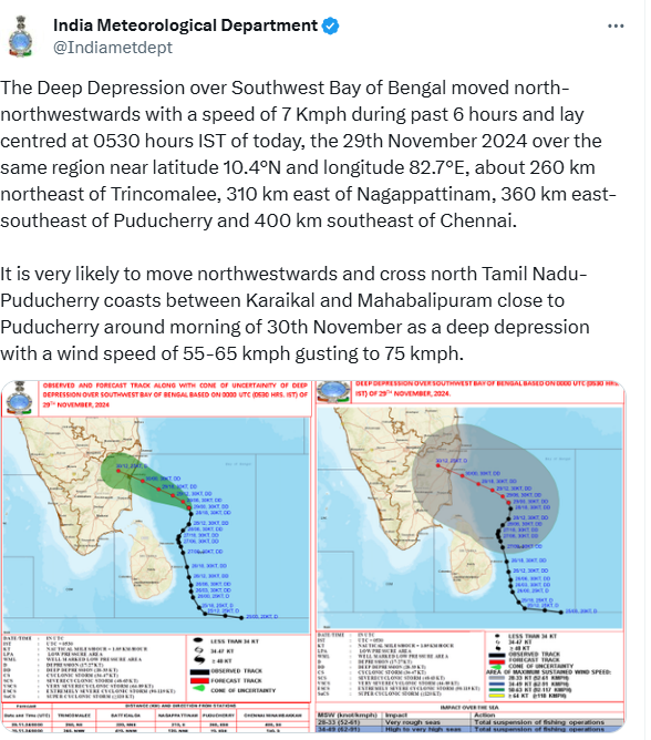
The Deep Depression over Southwest Bay of Bengal moved north-northwestwards with a speed of 7kmph in the past six hours and lay centred at 5.30am today, over the same region about 260 km northeast of Trincomalee, 310 km east of Nagappattinam, 360 km east-southeast of Puducherry and 400km southeast of Chennai.
It is very likely to move northwestwards and cross north Tamil Nadu-Puducherry coasts between Karaikal and Mahabalipuram close to Puducherry around morning of November 30 as a deep depression with a wind speed of 55-65 kmph gusting to 75 kmph.
Chennai Rain Live: Cyclone fengal triggers heavy rainfall, submerges over 800 acres of Paddy in Tamil Nadu's Nagapattinam
Heavy rainfall caused by Cyclone Fengal on Thursday has severely impacted Tamil Nadu's Nagapattinam district, with over 800 acres of paddy crops completely submerged, leaving farmers in distress.
The affected areas include Kamashwaram, Virundhamavadi, Pudupalli, Vedrappu, Vanamadevi, Vallapallam, Kallimedu, Eeravayal, and Chemboadi, where widespread crop damage has been reported.
4o
Chennai Rain Live Updates: Deep depression over Bay of Bengal likely to weaken near TN, Puducherry coasts
The deep depression over the Southwest Bay of Bengal, initially predicted to intensify into a cyclonic storm, is now expected to gradually weaken into a depression as it nears the north Tamil Nadu and Puducherry coasts.
The India Meteorological Department (IMD) stated that the system is likely to move northwestward, maintaining its intensity as a deep depression until November 29, 2024, before weakening into a depression as it approaches the coasts.
The depression is forecast to make landfall between Karaikal and Mahabalipuram, close to Puducherry, by the morning of November 30. After it reaches the coast, the system will bring moderate winds, with speeds ranging between 45 and 55 km/h, gusting up to 65 km/h, along with heavy rainfall in coastal regions.
Chennai Rain Live: Deep depression stationary over Bay of Bengal, to cross Karaikal-Mahabalipuram, says IMD
The deep depression over the Southwest Bay of Bengal remained nearly stationary, located about 100 km east-northeast of Trincomalee.
According to the Regional Meteorological Centre, Chennai, it is expected to intensify into a cyclonic storm within the next 12 hours.
The system will move north-northwestwards, skirting the Sri Lanka coast, and is likely to strengthen into a cyclonic storm during this period, the RMC said in its latest bulletin.
"To cross the north Tamil Nadu-Puducherry coasts between Karaikal and Mahabalipuram around the morning of November 30, as a deep depression with a wind speed of 50-60 kmph gusting to 70 kmph," it said.
Chennai Rain Live: Depression to cross TN-Puducherry coast on Saturday morning, says IMD
The India Meteorological Department (IMD) stated on Friday that the deep depression over the Bay of Bengal is "very likely" to cross the coast as a depression on November 30, between Tamil Nadu and Puducherry.
The deep depression over the Southwest Bay of Bengal moved north-northeastwards at a speed of 9 kmph over the past six hours and, as of 11:30 PM on November 28, was centered over the same region. It lay approximately 240 km northeast of Trincomalee (Sri Lanka), 330 km east-southeast of Nagappattinam, 390 km east-southeast of Puducherry, and 430 km southeast of Chennai, according to the weather office's latest update on 'X.'
Chennai Rain Live: Indian Coast Guard evacuates 6 stranded fishermen, 4 workers from Cuddalore Chemplast jetty
The Indian Coast Guard (ICG) successfully rescued six stranded fishermen and four workers from the Chemplast jetty in Cuddalore, situated approximately 2 km offshore, despite deteriorating weather conditions on Thursday.
"In a remarkable #SearchAndRescue operation, @IndiaCoastGuard safely evacuated six stranded fishermen and four workers from the #Cuddalore Chemplast jetty, about 2 km into the sea, amidst deteriorating weather conditions. Kudos to our brave crew for their unwavering commitment and swift action. #RescueMission," the ICG posted on X.
Cyclone Fengal: Schools closed today amid heavy rain in Chennai, IMD issues red alert for heavy rainfall
In view of heavy rain, Chennai district collector Rashmi Siddharth Zagade has announced a holiday for schools on Friday.
Chengalpettu district has also declared a holiday for schools due to heavy rain on Friday. Read more
Chennai Rain Live: Change in landfall location
As a result of the system's northerly and northwesterly movement, which covered only 75 km in 24 hours, the location of the anticipated landfall has shifted.
Originally, the system was expected to make landfall farther north, but now it is projected to strike closer to the southern coastal regions, between Karaikal and Mamallapuram. This change in the landfall location is a direct result of the slow movement and altered course of the deep depression.
Chennai Rain Live Updates: Impact of environmental factors
The IMD has explained that a combination of environmental factors has slowed the system's development. The deep depression's interaction with the coast of Sri Lanka, reduced low-level convergence, and the presence of an upper-tropospheric ridge (an area of high atmospheric pressure) has resulted in the system's slow movement and prevented it from intensifying. This slow progression has altered the rainfall patterns, with the system’s impact expected to be more prolonged rather than intensified.
Chennai Rain Live: Rainfall predictions for Tamil Nadu
The IMD forecasts that on November 29, 19 districts from Chengalpet to Nagapattinam and adjoining areas will receive rainfall ranging from heavy to extremely heavy. On November 30, the north coastal districts, including 24 districts from Tiruvallur to Cuddalore, are likely to experience extremely heavy to heavy rainfall. This rainfall is expected to bring the potential for flooding and waterlogging, especially in areas that are already prone to such conditions.
Chennai Rain Live: Slow movement of the deep depression delays intensification
The deep depression has been moving very slowly, at a rate of about 3 km/h, which has delayed the expected intensification into a cyclone. This slow movement is due to several factors, including reduced low-level convergence and an upper-tropospheric ridge, which affects atmospheric pressure. As a result, the rain intensity is not expected to drastically change, though heavy rain is still forecasted. The rain could begin on Friday morning or afternoon and continue into the weekend.
Chennai Rain Live: Deep depression to weaken
According to the IMD, the deep depression will continue as a deep depression until the morning of November 29, before weakening further into a depression. The system’s slow-moving nature, combined with the lack of significant change in atmospheric conditions, has reduced the likelihood of cyclone formation. Despite this, rainfall is still expected to impact the region, particularly as the system makes landfall.
Chennai Rain Live: IMD issues alerts for Chennai and surrounding areas
The India Meteorological Department (IMD) has issued an orange alert for Chennai on November 29, warning of heavy to very heavy rainfall. On November 30, the alert level increases to red, indicating the possibility of extremely heavy rainfall at one or two locations.
This red alert also extends to Kancheepuram, Tiruvallur, and Chengalpet districts, which are likely to experience intense rainfall as the system moves northward, though the intensity may not significantly change due to the slow movement of the system.
Chennai Rain Live: Heavy rain expected on November 29-30
The city of Chennai and its surrounding neighborhoods are likely to experience significant rainfall on November 29-30 due to the deep depression located 470 km southeast of Chennai.
Initially forecast to intensify into a cyclone, the system is now expected to weaken into a depression by Friday evening.
While the cyclone formation has been ruled out, heavy rain will still occur, with the system expected to make landfall between Karaikal and Mamallapuram on Saturday morning.
All Comments ()+^ Back to Top
Refrain from posting comments that are obscene, defamatory or inflammatory, and do not indulge in personal attacks, name calling or inciting hatred against any community. Help us delete comments that do not follow these guidelines by marking them offensive. Let's work together to keep the conversation civil.
HIDE