- News
- Technology News
- Hack of the day: Check air quality before outdoor plans
Trending
Hack of the day: Check air quality before outdoor plans
What are air quality scales
How air quality indexes are calculated
- Particulate Matter, like PM2.5 and PM10
- Ozone (O3)
- Nitrogen Dioxide (NO2)
- Sulfur Dioxide (SO2)
- Carbon Monoxide (CO)
- The European AQI reports on the 6 separate pollutants mentioned above.
- The India AQI reports the pollutants above and on ammonia (NH3).
Air quality influences
- Weather conditions like wind speed and direction, and relative humidity among others.
- Solar irradiance
- Wildfires and other types of fires
- Agriculture dust storms and dust emissions
- Industry and private households emissions
- Traffic emissions
- Other physical and chemical atmospheric processes
- Station-based solution specific
How Air Quality Index (AQI) near you is selected
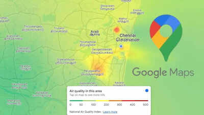
How to check air quality using Google Maps
- Sign in to Google Maps.
- On the location header, select Choose area.
- To use precise location, change location.

About the AuthorNeha Saini
End of Article
Latest Mobiles


Follow Us On Social Media
Hot Picks
Top Trending
Tired of too many ads?go ad free now
Trending Stories
In Section
Entire Website
- Anthropic releases a version of AI model that has scared governments and banks across the world; says ‘To release the model …’
- Google Cloud outage update: Fire at data centre, Traffic rerouted from impacted facility in Delhi
- Meta's highest-paid employee Alexandr Wang sends 'health message' to Anthropic, OpenAI, Google and others with AI models: Our models will ...
- Bill Gates to Amazon, Google, Meta, Microsoft and every other company building data center in the US: Communities will not accept data centers that...
- EU orders Meta to give OpenAI and other AI rivals free access to WhatsApp
- Belkin Lilypad case for iPad launched in collaboration with Disney and Pixar's Toy Story 5
- Anthropic's Claude Fable 5 is here: The Mythos-class AI model anyone can now use and what makes it different
- As survey claims exodus of businesses from Washington over Millionaires tax, Seattle’s mayor boasts of donations from Starbucks, T-Mobile and Microsoft for her ...
- Salesforce reportedly lays off employees working on Agentforce AI product that CEO Marc Benioff once said that company may change its name to
- Angry with researcher for publishing unpatched bugs, Microsoft to go for criminal investigation; says: Our Digital Crimes Unit will ...
- US-Israel-Iran War News Live Updates: 'Very close to strong powerful deal' - Trump sees path to Iran deal despite latest escalation
- From working in a restaurant to leading HubSpot: Yamini Rangan's journey to the top
- 'Son unlike father': Nitish Kumar’s son Nishant studied engineering but never graduated, MLC affidavit shows
- Inside India's ODI dressing room: Why Gautam Gambhir and Shubman Gill must act before 2027 World Cup
- Hardik Pandya to miss Afghanistan ODIs due to low-grade quadricep sprain
- Watch: Lionel Messi silences injury concerns with stunning penalty in Argentina's 3-0 win vs Iceland
- DHSE Kerala Plus One Result 2026 Live Updates: Kerala Class 11 result to be out shortly as over four lakh students await scorecard release; check steps to download marksheet
- TNEA Random Number 2026 out today: Link and steps to check here
- "She's angry": Blake Lively faces fresh setback as Taylor Swift and Travis Kelce prepare for lavish wedding
- “I had to let him find someone else”: Dwyane Wade's wife Gabrielle Union breaks silence on why she wanted to end their marriage
Tired of too many ads?go ad free now


Explore Every Corner
Across The Globe
Virat KohliUS Iran WarUS Strikes IranMeenakshi NatarajanStock Market TodayGold Rate TodayAuston Matthew Car CollectionDelhi Hotel FirePM ModiFIFA World Cup Full ScheduleBen StokesIran Drone AttackFIFA World Cup 2026Pakistan AirstrikesYamini RanganKerala DHSE Result AlternativesMeerut Conversion CaseBareilly NewsHardik PandyaHyderabad rainDelhi weatherDK ShivakumarTelangana monsoonKuwait worker recruitmentTNEA Random Number 2026DHSE Kerala Plus One Result 2026Gautam GambhirSahibzada FarhanNHL Trade RumorOmar Abdulkadir

Hot on the Web
Ravi MohanBharathiraja Death NewsBuchi Babu SanaBadshahSalman KhanNarendra Modi DietFabrice BellardNeil BhattAly GoniSapna ChoudharyBigg Boss 20Armaan MalikLow Cost Retirement PlacesMarie CurieValparaiTrevor Dietz Death NewsSandhya MridulJacqueline FernandezKangana RanautCardi BRavi ShastriIllegal Construction RulesHimanshu JangraTaylor SwiftDrishyam 3 Box Office CollectionBharathiraja DeathEva GroverBlast Box Office CollectionPankaj BhadouriaHoroscope TodayNuclear Weapons SpendingPostal Department PenaltyAir Asia Court OrderQuantum States For SensorsNissan Gravite MPVHuman Evolving On Tibetan PlateauLargest Islands In The WorldModern Day BrahmastraGoogle Release MosquitoesIndia Nuclear WarheadsNyt ConnectionsCaptions For Instagram Posts
Trending Topics
Rajasthan BSTC Result 2026Unemployed GraduatesSabyasachi DuttaMamata BanerjeeOTET Exam Rescheduled 2026Ruturaj GaikwadNEET UG Re-Exam 2026Kerala Plus One Result 2026Blake LivelyJesse RidgwayBen StokesKerala DHSE Plus One result 2026IShowSpeedJason Kelce and Kylie Kelce net worthFortniteInde NavarrettesDianna RussiniKelly StaffordErling HaalandCristiano RonaldoIran WarPakistan AirstrikesIran Drone AttackDonald TrumpUS Strikes IranBelfast attackPoK ProtestsMLB Trade RumorCaitlin ClarkBTSWalmart ShareholdersMicrosoft Criminal InvestigationWashington Millionaire TaxMarc BenioffClaude Fable 5EU Orders MetaApple Headquarters ProtestIOS 27 Supported DevicesGarena Free Fire MAX Redeem CodesPeroxide CodesGenshin Impact Codes
Popular Categories
HeadlinesSports NewsBusiness NewsIndia NewsWorld NewsInternational SportsHealthBreaking NewsTravelAstrologyDeorhiTOI Young LeadersTOI Home Decor AwardsPower Creator Awards 2026TOI Ecopreneur Awards 2026Gold Rate TodayWeather TodaySilver Price TodayDelhi Weather TodayPetrol Price TodayDiesel Price TodayCNG Price TodayLPG Price TodayPetrol Price MumbaiDelhi AQIIs Bank Open TodayMumbai AQI TodayIs Bank Open TomorrowPublic Holidays in JuneBank Holidays in June
Trending Videos
TMC Faces Fresh Rebellion As MPs Cozy Up To NDA, Shatrughan Sinha's Silence Raises QuestionsIran Blasts World Cup Visa Chaos As Fan Ticket Dispute Triggers Major FIFA Controversy10 JUNE HOROSCOPE 2026TODAY’S COSMIC SHIFT CAN CHANGE YOUR DESTINY | Times MantraBig! Iran Attacks 5th Fleet HQ Of US Navy In Bahrain; 'More Severe Response Is Coming'Germany Demands Answers As Calls Grow For Ukraine Reparations Over Nord Stream Pipeline SabotageUrabba - Official TrailerWhalefall - Official TeaserIran’s IRGC Strikes US Bases In Mideast; 'Severe & Widespread Strikes If Attacks Continue'Indus Waters Treaty In Abeyance: Centre Says Pakistan Won't Get 'A Single Drop' Of WaterRiots, Fires And Unrest Rock Belfast; Knife Attack Sparks Total Mayhem | Northern Ireland BurnsMamata Banerjee's Rare Meeting With Sonia Gandhi Sparks Speculation Of Opposition Realignment'WAR ROUTES UNDER HEAVY FIRE': Russia Unleashes Devastating Strikes On Ukraine Supply NetworkAfter F-35 BASE Claims, Reports Suggest Israel’s Ew Hq May Also Have Been Targeted In StrikeViral Footage Emerges After Trump Claims Iran Downed US Apache Near Strait Of HormuzSarah Ferguson Reacts To Staff Revolt As New Claims Rock Royal Circles | WATCHChip Roy Brutally Grills SPLC Boss: ‘How Many Leftists, Anti-Jewish, Islamists Have You Listed?’'Todd Blanche A Disgrace, Real Fraud': Jamie Raskin Unleashes During SPLC Hearing‘You Used Donor Funds For Extremist Rallies?’: Jim Jordan Confronts 'Speechless' SPLC Chief
Latest News
Hazaribag man drowns while fishing in lake"Behen Darr Gayi!": Fans relive ‘Bhagam Bhag’ era after watching Akshay Kumar's 'Bhooth Bangla' trailerMBOSE HSLC result 2026 to release tomorrow: Check details hereIran war risk: JPMorgan CEO Jamie Dimon warns of oil shocks, sticky inflation and higher interest ratesMake your clutch last longer with these easy driving tips“Three-against-one situation”: El Rubius opens up on being “targeted” in MrBeast’s viral $1M challengeBihar BTSC lab assistant notification released for 1091 posts at btsc.bihar.gov.in; apply hereIPL craze costs techie Rs 1.46 lakh in fake RCB vs CSK ticket scamRaising “robot-proof” kids: Why creativity and curiosity matter more than everInside ‘Satguru Sharan’: Exploring Saif Ali Khan and Kareena Kapoor Khan’s Rs 100 crore Bandra homeHow selling Alaska in 1867 was a costly mistake for Russia'Hera Pheri 3 is coming': Paresh Rawal dismisses delay reports and reveals he will 'start shooting soon'US-Iran War: A daring rescue Hollywood blockbuster is on its way. Till then, pick your favourite from these 10 films on bringing someone home against all oddsKolkata team unveils fan mural at Rash Behari Avenue, celebrating city’s first loveHow US spread a lie to rescue a pilot of a jet shot down in IranNetflix unveils ‘VOID’, an AI model that can change a movie plotAI data centers are causing 'stress' not just to tech companies, but also private insurers"Trans women are.....": Clavicular’s viral moment with trans women sparks fresh conversation on internet culture
Copyright © 2026 Bennett, Coleman & Co. Ltd. All rights reserved. For reprint rights: Times Syndication Service