- News
- City News
- ranchi News
- Rain to intensify, monsoon to weaken from Sunday: IMD
Trending
This story is from September 23, 2023
Rain to intensify, monsoon to weaken from Sunday: IMD
Weather scientists at the India Meteorological Department’s (IMD) Ranchi office on Friday predicted that rainfall activities, accompanied by thunder and lightning, would continue over the state and most districts would receive light to moderate showers till Monday even though its intensity would gradually wane.

Heavy rain, the IMD said, was recorded in Sundarpahari in Godda (160.2mm), Deoghar (135.6mm), Sahibganj (123.5 mm), Pakartand in Simdega (113.8 mm), Sarath in Deoghar (110.2mm), Hazaribagh (97mm), Dumri in Giridih (68 mm) and other places, affecting life and outdoor activities.
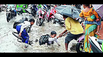
Ranchi received 10.9 mm of rain overnight and it continued to drizzle throughout Friday. The constant rain turned many low-lying areas of the city into swamps. Under-construction drainage and water supply lines across the city’s arterial roads proved to be commuter’s nightmare. Waterlogging was also reported from Hinoo, Kantatoli Chowk, Ratu Road and several residential pockets in Chutia localities.
“The low-pressure area, which lay on western Jharkhand on Thursday, has moved northwestwards on Friday. Under its influence, northwestern and northeastern districts of the state will receive heavy to very heavy rains in the next 24 hours. From Saturday onwards, the intensity of the rain would gradually wane,” Abhishek Anand, a weather scientist at IMD Ranchi said.
The state’s rainfall deficit was considerably reduced by the ongoing wet spell.
While Jharkhand’s rainfall deficit was 33% on September 20, it was down to 29% on Friday evening. As of Friday, Jharkhand had received rainfall of 688.6 mm compared to its normal average of 970 mm.
We also published the following articles recently
No heavy rain on Monday, says IMD
Despite the forecast of light to moderate rainfall in parts of Andhra Pradesh, citizens are flocking to markets to complete their shopping for the upcoming Ganesh festival. Thunderstorm activity is expected to continue in certain areas, but heavy rainfall is unlikely. Skilled artisans from various parts of the state have set up pandals for residents to enjoy the festivities. In other news, heavy rain has caused flooding in Massachusetts and Rhode Island, leading to evacuations and school closures. Rajasthan has also experienced heavy rainfall, with more expected in the coming days.
Despite the forecast of light to moderate rainfall in parts of Andhra Pradesh, citizens are flocking to markets to complete their shopping for the upcoming Ganesh festival. Thunderstorm activity is expected to continue in certain areas, but heavy rainfall is unlikely. Skilled artisans from various parts of the state have set up pandals for residents to enjoy the festivities. In other news, heavy rain has caused flooding in Massachusetts and Rhode Island, leading to evacuations and school closures. Rajasthan has also experienced heavy rainfall, with more expected in the coming days.
IMD issues yellow alert for Northeastern Telangana, heavy rain expected
The India Meteorological Department has issued a yellow alert for heavy rains in North and Northeastern parts of Telangana. The alert is in effect for today and tomorrow, with specific areas such as Mancherial, Kamareddy, and Nizamabad expected to be affected. A low-pressure system in the Northeastern part of the Bay of Bengal has led to the formation of an upper air circulation, resulting in rainfall across Telangana. Hyderabad is expected to experience cloudy conditions and rain, with intense spells of rain and thundershowers forecasted for tomorrow.
The India Meteorological Department has issued a yellow alert for heavy rains in North and Northeastern parts of Telangana. The alert is in effect for today and tomorrow, with specific areas such as Mancherial, Kamareddy, and Nizamabad expected to be affected. A low-pressure system in the Northeastern part of the Bay of Bengal has led to the formation of an upper air circulation, resulting in rainfall across Telangana. Hyderabad is expected to experience cloudy conditions and rain, with intense spells of rain and thundershowers forecasted for tomorrow.
IMD sounds fresh rain alert till Friday
A fresh low pressure area over the Bay of Bengal is expected to bring widespread rainfall in some areas of Odisha till Friday, with heavy to very heavy rainfall predicted in coastal and interior districts. The forecast comes after light to moderate showers during Ganesh Chaturthi on Tuesday. Similarly, Hyderabad and parts of Telangana are also likely to experience heavy rainfall due to a new low-pressure area. Additionally, Goa, Maharashtra's Konkan region, and various parts of Maharashtra have been issued warnings for heavy rainfall.
A fresh low pressure area over the Bay of Bengal is expected to bring widespread rainfall in some areas of Odisha till Friday, with heavy to very heavy rainfall predicted in coastal and interior districts. The forecast comes after light to moderate showers during Ganesh Chaturthi on Tuesday. Similarly, Hyderabad and parts of Telangana are also likely to experience heavy rainfall due to a new low-pressure area. Additionally, Goa, Maharashtra's Konkan region, and various parts of Maharashtra have been issued warnings for heavy rainfall.
End of Article
FOLLOW US ON SOCIAL MEDIA


Photostories

Hot Picks
TOP TRENDING
Popular Categories
Hot on the Web
Top Trends
IND vs AUS Live ScoreBaba Siddique NewsVirat KohliRussell WilsonsSpacex StarshipRahul DravidWho was Baba SiddiqueBabar AzamNTA SWAYAM July RegistrationLawrence BishnoiAmazon LayoffsTaylor SwiftManagement Colleges of IndiaTop Medical Colleges of IndiaTop Engineering Colleges of IndiaTop Pharmacy Colleges of IndiaLive Cricket Score
Trending Topics
Diwali WishesDussehra 2024 QuotesDussehra WishesVettaiyan OTT ReleaseVettaiyan CollectionVettaiyan ReviewNatasa StankovicDevara CollectionBigg Boss 18Deepika PadukoneShraddha KapoorRatan Tata Passed AwayJigra Movie ReviewVettaiyan Movie ReviewSwatantrya Veer SavarkarDussehra 2024Star Health Hacker DemandedViral MemesUltimate Football Codes October 2024Wordle Answer
Living and entertainment
Latest News
Accused did recce of Baba Siddiqui's house, monitored him for months: Mumbai PoliceParas Mhambrey joins Mumbai Indians as bowling coachSalman Khan’s security beefed up after Baba Siddiqui’s murder; ‘Sultan’ star looked uncomfortable after visiting the late politician’s family at 3 amBaba Siddique may have died prior to hospitalisation, says doctorsSpaceX's fifth Starship test flight achieves historic booster catchKrushna Abhishek shares a heartwarming post for mama Govinda; says 'jab body mein adha blood supremely talented actor Govinda ka ho...'News brief: 'Who is listening? Modi?': Kapil Sibal takes a dig at RSS chief Mohan BhagwatZodiac signs likely to have soul connectionsAI’S Oppenheimer'Points towards failure of CM': Sanjay Raut slams Maharashtra govt over Baba Siddiqui's killingMahela Jayawardene returns as Mumbai Indians head coachMidnight queues, long waits, bad advice: It's not easy getting therapy in IndiaTom Brady is Likely to Become a Minority Owner of Las Vegas Raiders at the Upcoming NFL Fall Owners' Meeting4.2 magnitude earthquake strikes AssamThe Great Indian Kapil Show 2: Kareena Kapoor reveals hubby Saif Ali Khan is jealous of her bond with sister Karisma; says, “He thinks I talk to her more than him”Accused were paid in advance to kill Baba Siddique: Mumbai PoliceMammograms and breast cancer treatment: Separating facts from mythsHow vitamin C-rich foods help with weight loss
Copyright © 2024 Bennett, Coleman & Co. Ltd. All rights reserved. For reprint rights: Times Syndication Service