- News
- City News
- hubballi News
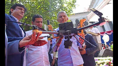
- Karnataka to deploy 5,000 GPS rovers to transform land survey system
Trending
Karnataka to deploy 5,000 GPS rovers to transform land survey system
End of Article
Follow Us On Social Media

Hot Picks
Top Trending
Tired of too many ads?go ad free now
Trending Stories
In City
Entire Website
- Check-in to courtroom: Hotel guest told to pay over Rs 16 lakh for not paying dues
- 'Khalistan will be established soon': Grenade lobbed at Punjab BJP office in Chandigarh; watch chilling video
- Deadlock in six seats, Annamalai’s candidature holds up BJP’s candidate list
- To cure son's illness, daughter killed in 'sacrificial ritual' in Jharkhand; mother, tantrik among 3 arrested
- A cloak of stars and trail of scars: The dark orbit of 'astrologer' Ashok Kharat
- Hyderabad doctor dies by suicide after injecting himself with poison; abetment case filed against wife
- New electricity supply rule in Telangana sparks outcry, mandatory occupancy certificate for connections hits renovated buildings
- ‘Irresponsible remark’: MP Mahua Moitra’s comments on 'Gujaratis' spark row in Mamata Banerjee's fief; TMC apologises
- 51% of CCTVs China-made, Delhi plans phased removal over security concerns
- ‘Danger’ written on tissue delays Mumbai–Ahmedabad IndiGo flight by over 8 hours
- US-Israel-Iran War Live Updates: Drone attack targets Kuwait airport, fuel tanks on fire; Iran threatens to target key US companies
- Nasa Artemis II Moon Mission Launch Live Updates: Nasa prepares to send 4 astronauts in lunar orbit for 1st time since 1972
- Check-in to courtroom: Hotel guest told to pay over Rs 16 lakh for not paying dues
- Quote of the day by Andrew Carnegie: "The way to become rich is to put all your eggs in one basket and then watch that basket."
- 'Buy from US or go take it from the Strait': Trump's suggestion to nations hit by oil shock due to Hormuz crisis
- Iran endgame, gas prices, Strait of Hormuz crisis & more: Key takeaways from Donald Trump's big address
- Indian-origin US doctor reacts to Oracle layoff, says every single H-1B should be sent back home
- Ex-Pakistan batter slams PCB after Naseem Shah fined PKR 20mil for 'Queen' jibe
- Fact check: Is Taylor Swift stepping in to replace Sabrina Carpenter at Coachella 2026 amid health issues ahead of her wedding to Travis Kelce?
- Census 2027 begins: President Murmu, PM Modi among leaders completing self-enumeration
Tired of too many ads?go ad free now


Explore Every Corner
Across The Globe
Israel Iran WarTelangana New Electricity RuleLPG Shortage IndiaOracle Laid OffHormuz CrisisCrude Oil PriceHarry KaneDonald TrumpArjun TendulkarPunjab BJP office blastSanjiv GoenkaCameron GreenKL RahulFakhar ZamanCooper ConnollyJames AndersonMrBeastArtemis 2 LaunchH-1B visaLuanne JamesSerena WilliamsTed BundyTiger WoodsScott MillsMount Everest guidesRCB ticketsElliot CadeauIPL 2026IPL Schedule 2026IPL Schedule

Hot on the Web
Ramayana TeaserHanuman Jayanti 2026Nasa Artemis iiHanuman Jayanti MessagesRamayana Teaser Live UpdateHanuman Jayanti WishesViveck VaswaniTooth Enamel ProtectionVegetarian Friendly CountriesDhurandhar 2 Box Office CollectionTarun Mishra StoryJennifer MistryChef Sanjeev KapoorSnake Hole vs Rodent HoleMark TwainRam Gopal VarmaDhurandhar 2 ReviewSourav Ganguly biopicUstaad Bhagat Singh CollectionRanbir KapoorStrawberries Growing TipsCardi BDhurandhar 2 CollectionAkshay KumarApril Pink MoonVicky KaushalMovierulzAadu 3 Box Office CollectionHoroscope TodayHoroscope TomorrowToday Gold Rate in ChennaiDelhi Weather TodayDelhi AQI TodayMumbai AQI TodayMaharashtra Public Holidays 2026Israel Secret AIApple iPhone 18 ProMassive x1.4 Solar FlareGarena Free Fire MAX Redeem CodesKitkat Bars Stolen In EuropeBasketball Zero Codes
Trending Topics
Harry BrookParthiv PatelGiannis AntetokounmpoAyesha CurryTravis KelceEvander KaneStefanos TsitsipasMartina NavratilovaCardi BWinnipeg JetsStephen A SmithMrBeastTaylor SwiftEmma RaducanuDayton WebberMegan Thee StallionLucas di GrassiEdoardo MortaraJack PughPaige SpiranacJaxson DartBlake LivelyIShowSpeedLas Vegas RaidersTed BundyScott MillsLas Vegas RaidersManny PacquiaoIPL Broadcast Engineer DeathHyderabad Murder NewsPalmer LuckeyFastag Annual PassOracle LayoffsClaude Source Code LeaksMustafa SuleymanDeloitte HiringApril Pink MoonArtemis iiScience NewsHow to watch ICC T20 World Cup 2026 in USAIPL 2026IPL Schedule 2026
Popular Categories
HeadlinesSports NewsBusiness NewsIndia NewsWorld NewsBollywood NewsHealth+ TipsIndian TV ShowsTechnologyTravelEtimesHealth & FitnessAstrologyInternational SportsDeorhiTechnology NewsAutoWeather TodayGold Rate Today DelhiSilver Rate TodayPlatinum Rate TodayIs Bank open todayVirat Kohli IPL StatsHardik Pandya IPL StatsBank HolidaysPublic HolidaysBank Holidays AprilPublic Holidays AprilAries HoroscopeGemini Horoscope
Latest News
NTA JEE Mains admit card released for April 5 to 8 papers: Direct link to download hereAnne Hathaway’s one major condition for The Devil Wears Prada 2 will make you respect her even more'Remember standing on those grounds': Astronaut Shubhanshu Shukla recalls Moon journey, hails Artemis II launchBulk food packs won’t slip through anymore: FSSAI tightens label rules, rollout from 2027Candidates: Javokhir Sindarov takes commanding lead; Zhu Jiner beats Divya DeshmukhMoon mission: Artemis II crew report issue with Orion spacecraft toilet; NASA troubleshootsThe 50-copy rule where copyright fades‘Rotten tomatoes, obscene photos’: Dutch national sends 'bizarre' parcel to Bengaluru airport to prevent 'untoward' incidentsBata to step up India growth, double turnover in 5 yrsBihar SHS ANM merit list 2026 released at shs.bihar.gov.in: Direct link to download here'No compulsion to watch the matches': Madras high court refuses urgent hearing on IPL postponement plea‘Everything was a blur after I scored’: Ryan Williams after successful India debutExclusive - Toral Rasputra returns with 'Hastinapur Ke Veer' to play the role of Kunti; says 'The depth and complexity of the character really excited me as an actor'‘Pudhupettai’ to ‘Vada Chennai’: Must-watch Dhanush films you can stream on OTT platforms nowRare 1000-year-old Quranic manuscript unveiled in Saudi ArabiaMani Sharma recalls comeback moment with ‘Chennai Love Story’: 'After one tune, I realised music is still within me'IPL 2026: KKR see Cameron Green as a long-term prospect'This is Fraud': MAGA accuses Indian-Americans of O-1A visa scam, claim agencies offering H-1B 'workaround'
Copyright © 2026 Bennett, Coleman & Co. Ltd. All rights reserved. For reprint rights: Times Syndication Service