- News
- City News
- chandigarh News
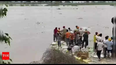
- NGT pulls up Punjab over delay in floodplain demarcation along Satluj, seeks timeline
Trending
NGT pulls up Punjab over delay in floodplain demarcation along Satluj, seeks timeline
Get real-time updates and result insights on the CBSE 12 Result 2026.
You Can Also Check: Gold Rate in Chandigarh | Silver Rate in Chandigarh | Bank Holidays in Chandigarh | Public Holidays in Chandigarh | Chandigarh AQI | Weather in Chandigarh


About the AuthorVinod Kumar
End of Article
Follow Us On Social Media
Hot Picks
Top Trending
Tired of too many ads?go ad free now
Trending Stories
In City
Entire Website
- 'Fake' caste certificate row: AIMIM corporator Sahar Sheikh’s father denies charges, calls it ‘political stunt’
- CBSE Class X results: Toppers eye non-medical stream, engineering careers
- Maharashtra: Thane municipal commissioner orders to make Ghodbunder Highway free of hawkers
- Delhi-Dehradun Expressway ease ends in gridlock as Saharanpur road chokes entry
- Govt to start demolition drive in Gurgaon after Punjab and Haryana high court stays S+4 policy, DLF-1 first
- ‘Relative took her to Nashik’: SIT forms 3 teams to trace absconding TCS employee; what husband told cops
- Saw exploitation at Axis Bank too, management took action, says CM Devendra Fadnavis’s wife Amruta
- Thane tehsildar recommends FIR over 'fake' OBC certificate used by BMC Mumbra corporator Sahar Sheikh's family
- TCS Nashik case: Woman who was 'repeatedly' referred to as HR manager held no leadership responsibilities, IT firm clarifies
- Karnataka Congress MLA Vinay Kulkarni gets life term for 2016 murder, faces disqualification
- US-Israel-Iran War Ceasefire News Live Updates: Iran mocks Trump’s ‘7 claims’ as ‘7 lies’, rejects Hormuz reopening claim
- RCB vs DC Live, IPL: David Miller seals six-wicket win for DC in last-over thriller
- Explained: On way to 4th largest, how India slipped to 6th rank & what it means for 3rd largest economy dream
- PM Modi Address To Nation Live Updates: PM Narendra Modi to address nation at 8:30 PM after women’s quota bill defeat
- CBSE Class 12 Result 2026 Live Updates: Result date, past trends, and how to check scores via DigiLocker, UMANG app, and SMS
- Jharkhand JAC Class 9 result 2026 released at jacresults.com: Direct link to download scorecards here
- JAC Class 12 result 2026: Inter result likely soon as Jharkhand Board enters final evaluation phase
- JAC class 10 result 2026: Jharkhand board matric result likely soon as evaluation nears completion
- 'I woke up and ... ': LizLaz breaks silence after Virat Kohli 'likes' then unlikes her pic
- Netanyahu shocked by Trump's post on Lebanon? Report claims Israel asked US for clarification
Tired of too many ads?go ad free now


Explore Every Corner
Across The Globe
US Iran War NewsPM Modi SpeechAbhishek SharmaWorld's Largest EconomySRH vs CSK Live ScoreTCS Nashik CaseRCB vs DC HighlightsLuka Doncic InjuryGT vs KKR highlightsUP Home Guard exam city slipRCB vs DC IPL MatchCSK vs SRH IPL MatchUP Board 10th ResultShaheen ShahCBSE Class 10 toppersAssembly Elections 2026Virat KohliMHT CET Result DateAP Polycet Hall TicketIPL match todayJAC 10th ResultVirat Kohli Like PostVirat KohliJAC 12th ResultSRH vs CSK Live ScoreAuston MatthewsIPL Orange CapIPL 2026 Points TableIPL 2026 NewsIPL Schedule 2026

Hot on the Web
Leo Tolstoy QuoteAkshaya Tritiya WishesBhoot Bangla ReviewSocrates QuoteBhooth Bangla Box Office CollectionShatrughan SinhaSavita PradhanKangana RanautBhooth Bangla ReviewShweta TiwariKishore KumarLIK CollectionAkshay KumarMr X Box Office CollectionDacoit Box Office CollectionNormal Movie ReviewCeiling FanLeonardo DicaprioDhurandhar 2 Box Office CollectionBaby NamesBhooth Bangla Movie ReviewShatrughan SinhaLiz LazVirat KohliSunny DeolLee Cronin's The Mummy ReviewDhurandhar 2 ReviewDhurandhar 2 CollectionMovierulzHoroscope TodayToday Gold Rate in ChennaiDelhi Weather TodayDelhi AQI TodayMumbai AQI TodayMaharashtra Public Holidays 2026Snap LayoffMackenzie ScottDemis HassabisLiz LazVinod KhoslaKing Legacy Codes
Trending Topics
Devendra FadnavisMumbai Fake OBC CertificateNashik TCSTCS Nashik CaseMaharashtra NewsGurgaon DemolitionDelhi Dehradun ExpresswayNashik TCS EmployeeIce Spice McDonalds FightMats Sundin MapleClavicular Overdose ControversyErika Kirk EventE Coli Smuggling CaseOlivia Dunne Net WorthArman TsarukyanSykkuno Girlfriend AllegationsAnderson Contract ExtensionAmit ShahDelimitation Bill DefeatPahalgam Pony Wallah StoryStalin Bill Defeat ReactionWomen Quota BillAntonio FelixAngie MentinkGiants Bears TradeAuston MatthewsSteven MillerShane LowryxQc Sick Sidemen Charity MatchJaguar GEN4 PrototypeSam AltmanElon MuskMark ZuckerbergJensen HuangJim FarleyAnthropic MythosGarena Free Fire Max Redeem CodesNyt ConnectionsScience NewsHow to watch ICC T20 World Cup 2026 in USAIPL 2026IPL Schedule 2026
Popular Categories
HeadlinesSports NewsBusiness NewsIndia NewsWorld NewsBollywood NewsHealth+ TipsIndian TV ShowsTechnologyTravelEtimesHealth & FitnessAstrologyInternational SportsDeorhiTechnology NewsAutoWeather TodayGold Rate Today DelhiSilver Rate TodayPlatinum Rate TodayIs Bank open todayVirat Kohli IPL StatsHardik Pandya IPL StatsBank HolidaysPublic HolidaysBank Holidays AprilPublic Holidays AprilAries HoroscopeGemini Horoscope
Latest News
Hazaribag man drowns while fishing in lake"Behen Darr Gayi!": Fans relive ‘Bhagam Bhag’ era after watching Akshay Kumar's 'Bhooth Bangla' trailerMBOSE HSLC result 2026 to release tomorrow: Check details hereIran war risk: JPMorgan CEO Jamie Dimon warns of oil shocks, sticky inflation and higher interest ratesMake your clutch last longer with these easy driving tips“Three-against-one situation”: El Rubius opens up on being “targeted” in MrBeast’s viral $1M challengeBihar BTSC lab assistant notification released for 1091 posts at btsc.bihar.gov.in; apply hereIPL craze costs techie Rs 1.46 lakh in fake RCB vs CSK ticket scamRaising “robot-proof” kids: Why creativity and curiosity matter more than everInside ‘Satguru Sharan’: Exploring Saif Ali Khan and Kareena Kapoor Khan’s Rs 100 crore Bandra homeHow selling Alaska in 1867 was a costly mistake for Russia'Hera Pheri 3 is coming': Paresh Rawal dismisses delay reports and reveals he will 'start shooting soon'US-Iran War: A daring rescue Hollywood blockbuster is on its way. Till then, pick your favourite from these 10 films on bringing someone home against all oddsKolkata team unveils fan mural at Rash Behari Avenue, celebrating city’s first loveHow US spread a lie to rescue a pilot of a jet shot down in IranNetflix unveils ‘VOID’, an AI model that can change a movie plotAI data centers are causing 'stress' not just to tech companies, but also private insurers"Trans women are.....": Clavicular’s viral moment with trans women sparks fresh conversation on internet culture
Copyright © 2026 Bennett, Coleman & Co. Ltd. All rights reserved. For reprint rights: Times Syndication Service