
- News
- Videos News
- india News
- Maharashtra Forest Department uses satellite imaging to track wildfires
Trending
Maharashtra Forest Department uses satellite imaging to track wildfires
| May 27, 2022, 04:46:26 PM | ANI
- Share
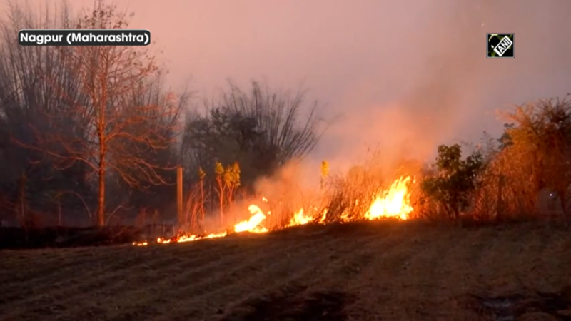
The Forest Department in Maharashtra has deployed a forest fire monitoring system that uses satellite imaging to track and contain incidents of forest fires. The Van Bhavan office in Nagpur uses satellite imaging of fires in remote areas, then relays the information to staff on the ground. Using geographical information system (GIS) technology, the National Remote Sensing Centre (NRSC) detects fires in the state. “With the help of satellite data, we determine the geo-coordinates of the fire site which are communicated to different forest teams which rush to the site to contain the fire,” said Kalyankumar P, Additional Principal Chief Conservator of Forests.
Recommended Playlist
- 03:32
 India Deploys GPS Jammers Near Pakistan Border After Pahalgam Attack | Details10 months ago
 - 03:09Seagull With China-Made GPS Device Near Karnataka Naval Base Triggers Spy Buzz; Here's the Truth2 months ago
- 02:19NISAR Will Help Global Community Monitor Earth Changes: ISRO Chairman V Narayanan7 months ago
- 03:05Satellite Images Reveal Indian Missile Strike On Pak Nuclear Site At Kirana Hills | Op Sindoor7 months ago
- 08:30We Will Give A Befitting Reply: BSF IG Issues Stern Warning To Pak-Based Terrorists Ahead of Winters4 months ago
- 03:32India Struck Pakistan's Nuclear Site At Kirana Hills Under Op Sindoor? Armed Forces Reveal Truth9 months ago
- 04:30US Approves Major Arms Deal For India With Javelins And Excalibur To Counter Regional Threats3 months ago
- 02:08Pakistan Using Drones To Smuggle Arms Into India, Punjab Police Busts Network, Recover Huge Cache4 months ago
- 04:01Pak Handler Shahzad Bhatti Directed Gurdaspur Grenade Attack: Special Cell3 months ago
- 03:45Rajasthan Police Nab Punjab Resident For Sharing Sensitive Army Details With ISI Handlers3 months ago


Top Viral Videos

- 04:00How Mr Cool Sanju Samson fired India into World Cup semis3.7K views | 2 days ago
- 03:15Nagpur: Deadly Factory Explosion, Global Tensions Hit Locals, Government Announces Aid And More716 views | 2 days ago
- 03:17Lucknow: Body Found In Freezer, Iran Conflict Protests, Student Death And More2.4K views | 2 days ago
- 08:44ON CAM: IRGC Drone Strikes U.S Military Base In Kuwait; Explosion Rocks Camp Buehring | WATCH22.0K views | 2 days ago


Short Videos


Explore Every Corner
Across The Globe
SA vs NZ Live ScoreDinesh KarthikMS DhoniAbhishek SharmaSarfarz AhmedIND vs ENG SemifinalMorne MorkelArjun Tendulkar WeddingAP SSC Hall TicketAbu Dhabi airport newsIND vs ENG Live StreamingMiddle East ConflictIran EarthquakeBengaluru Techie SuicideHyderabad Family SuicideBengaluru MurderVTU ResultWhat time Lunar Eclipse VisibleUS Israel School StrikeIran Israel ConflictUS Israel Iran WarUPSC CSE Final ResultSouth Africa vs New ZealandFlights cancellationBengaluru Hosur Road TrafficUS Strike IranMiddle East AdvisoryChandra Graham 2026India vs China Oil ReserveT20 World Cup 2026 Schedule
Hot on the Web
Vijay Deverakonda Wedding ReceptionHoli MessagesHappy Holi WishesThe Kerala Story 2Holi 2026 QuotesThaai KizhaviVijayRajinikanth Family TreeRashmika MandannaHoli QuotesChiranjeeviSelenelionNandamuri Balakrishna HouseLunar Eclipse 2026Katrina KaifChandra Grahan Time TodayAyesha KhanChris GardenerSunil Bharti MittalQatar AirportIran Travel Alert'O'Romeo' Box Office CollectionMumbai AirportLunar Eclipse City Wise TimingsYoung Sherlock ReviewHoroscope TodayThe 50The Bluff Movie ReviewBorder 2 Movie ReviewTu Yaa Main Movie ReviewToday Gold Rate in ChennaiDelhi Weather TodayDelhi AQI TodayMumbai AQI TodayMaharashtra Public Holidays 2026Anthropic Ceo Dario AmodeiHarsh GoenkaClaude DownLunar Eclipse Looks From MoonHoli Gadgets Safety TipsTotal Lunar Eclipse
Trending Topics
GPAT Admit CardUP Board Marks ImprovementOSSC CHSL NotificationMIT AI CoursesPakistan Cricket TeamAiden MarkramSouth Africa Cricket TeamNIOS Date SheetYIL Apprentice RecruitmentNeeraj PhogatCUET PG Admit CardAP SSC Hall TicketT20 World Cup Semi Final UmpiresGurgaon Faridabad Noida CorridorMiddle East CrisisHyderabad suicidePakistan Strike AfghanistanRainbow Six Siege Operation Silent Hunt Start TimeAbu Dhabi-Bengaluru flightAhmedabad college hostelBengaluru suicideSaudi Aramco oil refineryUndertaker net worthGeorge Kittle net worthCardi BJeff PassanNHL Injury UpdateWilliam NylanderNazem KadriOdisha reward schemeIntel Ceo Lip Bu TaniQoo 15RNintendo Indie World ShowcaseApple Macbook Air M5iPhone 17eElon MuskTikTok DownHoli Captions For InstagramApple iPad Air M4How to watch ICC T20 World Cup 2026 in USAHow to watch ICC T20 World Cup 2026 in CanadaHow to watch T20 World Cup online in India
Popular Categories
HeadlinesSports NewsBusiness NewsIndia NewsWorld NewsBollywood NewsHealth+ TipsIndian TV ShowsTechnologyTravelEtimesHealth & FitnessHow to watch T20 World Cup OnlineIndia vs Pakistan MatchAstrologyAutoWeather TodayGold Rate Today DelhiSilver Rate TodayPlatinum Rate TodayIs Bank open todayMarch Bank HolidaysMarch Public HolidaysDeorhiTechnology NewsInternational SportsPublic HolidaysBank HolidaysT20 World Cup Squad IndiaT20 Wprld Cup Squad
Trending Videos
'Monica Lewinsky Wore This…’: Bill Clinton's Epstein Deposition Erupts Over 'Blue Dress Painting'Hyderabad: Bizarre Poll Names, Economic Worries, Crime & MoreOmar Abdullah leads Srinagar prayers for Khamenei, Iran victimsMeet The Sheshnaag-150: India’s Answer To Cheap One Way Attack Drones '48 Hours After Modi Left...': Israel Envoy Reuven Azar Reveals When Netanyahu Approved Iran Strike'US Seeks To Halt India’s Rise Through Wars': Khamenei's Envoy's Shocking Revelation Blasts Trump
Latest News
AI war videos and hacked handles: X head of product Nikita Bier uncovers 31-account operationGoogle Photos for Android may get features that were exclusive to iPhone version: Here's what to expectRupee falls to all-time low of 92.05 against dollar as oil surge, foreign outflows rattle marketsWho is Aryna Sabalenka’s fiance Georgios Frangulis? All about the Brazilian businessman who proposed to the world No. 1 tennis starNFL Draft registration: How fans can register for the 2026 event in PittsburghIs Tom Brady behind the Maxx Crosby trade rumors? Bizarre Raiders details emergeNFL Trade Rumors: New York Giants interested in $36M Seattle Seahawks running backRashmika Mandanna-Vijay Deverakonda wedding reception: Allu Arjun, Ram Charan, Chiranjeevi, Nagarjuna, Venkatesh, Namrata attend'US, Israel will have complete control of Iran skies in few days,' says Pentagon chiefIt’s not you, it’s the pressure: Why modern parenting is so overwhelming‘We didn’t realise the danger’: Dhruv Rathee shares chilling Dubai escape storyHead Coach Jeff Blashill Says Connor Bedard Has Earned Alternate Captaincy with the Chicago BlackhawksWatch: Exact moment US strike hits Iranian ship, killing over 85Vijay Deverakonda’s ‘Telugu states new daughter-in-law’ remark leaves Rashmika Mandanna blushing at pre-reception press meetUS troops say Iran war briefings invoked Armageddon, the return of Jesus: ReportApple MacBook Air with M5 chip, WiFi 7 and double storage launched; Starts at Rs 1,19,900OpenAI is changing its contract with Pentagon; CEO Sam Altman says: I would rather go to jail than…CEO of Netflix who recently lost Warner Bros acquisition fight to Paramount says: They are buying a much larger company, debt that will force CEO David Ellison to layoff thousands and cut ...
Copyright © 2026 Bennett, Coleman & Co. Ltd. All rights reserved. For reprint rights: Times Syndication Service