- News
- City News
- vijayawada News
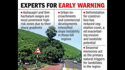
- 15% of Vizag hills vulnerable to landslides, study warns
Trending
15% of Vizag hills vulnerable to landslides, study warns
Israel attacks Iran
- US-Israel-Iran War Live Updates: 'Indian navy's guest struck without warning': Iran slams US after torpedo sinks warship IRIS Dena
- 'Will bitterly regret': Iran warns US after IRIS Dena, 'Indian Navy’s guest', sunk by torpedo
- What is Minuteman III missile? The 'doomsday' weapon US tested amid war with Iran


About the AuthorJinnala Umamaheswara Rao
End of Article
Follow Us On Social Media
Hot Picks
Top Trending
Tired of too many ads?go ad free now
Trending Stories
In City
Entire Website
- Chhattisgarh forest guard seen with woman companion thrashed, made to dance by mob; video sparks outrage
- Desi Maduro model, political abduction, leadership coup: Reactions pour in over Nitish Kumar's Rajya Sabha plan
- Akhilesh Yadav celebrates Holi in UP's Saifai and outlines SP push for 2027 elections
- 'I hope everything will be fine': Actor Sonu Sood reacts to US-Israel-Iran conflict; offers free stay for stranded travellers in Dubai
- Who killed Nancy Grewal? Family in Punjab alleges conspiracy after influencer’s murder in Canada
- Bengaluru UV radiation level hits ‘extreme’ 13: What you need to know
- Chennai MRTS extension nears launch: Velachery–St Thomas Mount set for March 10 opening
- Bengaluru cab driver overhears travel plans, returns at midnight to burgle locked house; steals gold worth Rs 25 lakh
- India vs England semi-final countdown: Abhishek Sharma, Axar Patel, Ishan Kishan visit Siddhivinayak Temple in Mumbai
- Nitish Kumar rewrites Bihar political script, set to leave CM post for Rajya Sabha
- US-Israel-Iran War Live Updates: Tanker hit by ‘large explosion’ off Kuwait, causing oil spill; Iran launches missiles at Israel
- Gold, Silver Rate Today Live Update: Gold, silver rise on continued Middle East crisis; investors run to safe haven assets
- India vs England Live Score, T20 World Cup Semi Final 2026: India, England battle for final berth; winner to face New Zealand
- Who killed Nancy Grewal? Family in Punjab alleges conspiracy after influencer’s murder in Canada
- Live: Arjun Tendulkar, Saaniya Chandhok tie the knot in grand ceremony – Watch
- What is Minuteman III missile? The 'doomsday' weapon US tested amid war with Iran
- ‘Not a choke, a bloody walloping’: Shukri Conrad’s brutal honesty after South Africa’s crushing T20 World Cup semifinal loss
- AP SSC Hall Ticket 2026 Live Updates: BSEAP Class 10 admit card to release soon at bse.ap.gov.in; steps to download here
- India Post GDS Result 2026 Live Updates: Merit list expected to be released soon; check expected cut-off marks
- UPSC CSE Results 2025 Live Updates: Final merit list expected to be released soon at upsc.nic.in, check important details here
Tired of too many ads?go ad free now


Explore Every Corner
Across The Globe
IND vs ENG Live ScoreRussian Crude OilNitish KumarConnor McDavidUS Israel Iran WarIsrael attack on IranIND vs ENG ScorecardSanju SamsonUPSC CSE ResultAP SSC Hall TicketAuston Matthews GirlfriendIND vs ENG SemifinalIsrael Iran WarMinuteman iii missileMiddle East conflictMaharastra Transporter StrikeBengaluru Techie SuicideGurtej Sandhu Education CareerArjun Tendulkar WeddingIndia Post GDS ResultIRIS Dena SunkWho is Shreya SinghalPAK Cricke Player Misconduct AllegationFAF DU PlessisIndian Cricket TeamMohammad KaifWho is Nalini AnantharamanShukri ConradRashid LatifT20 World Cup 2026 Schedule
Hot on the Web
Vijay Deverakonda Wedding ReceptionKuwait Visit Visa ExtensionArjun Tendulkar WeddingThe Kerala Story 2Lara DuttaThaai KizhaviVijayRajinikanth Family TreeRashmika MandannaOptical illusionChiranjeeviSelenelionNandamuri Balakrishna HouseDiksha PawarKatrina KaifMoscow AirportAyesha KhanChris GardenerSunil Bharti MittalQatar AirportIran Travel AlertDhurandhar 2Mumbai AirportSprout Chaat RecipeYoung Sherlock ReviewHoroscope TodayThe 50The Bluff Movie ReviewBorder 2 Movie ReviewTu Yaa Main Movie ReviewToday Gold Rate in ChennaiDelhi Weather TodayDelhi AQI TodayMumbai AQI TodayMaharashtra Public Holidays 2026Space JellyfishWord Of The Day PerspicaciousMark ZuckerbergSam AltmanMaruti 800 Into LamborghiniApple Macbook Neo
Trending Topics
IND vs ENG Live StreamingIndia vs England Match PreviewIndia vs England StatsJorfer ArcherMBBS BHMS BSC ResultsAiden MarkramSouth Africa Cricket TeamNIOS Date SheetYIL Apprentice RecruitmentNeeraj PhogatUP Fortuner crashPhulo Devi NetamMadras high courtNagarkurnool minorBengaluru businessman scamDelhi’s Rithala fireTelangana temple newsRohit PawarNavi Mumbai hit-and-runNitish KumarKarnataka's Malpe BeachPune holiBengaluru suicideMadras high courtBombay high courtBengaluru’s trafficMumbai car accidentKolkata senior citizensHooghly riverOdisha reward schemeYezdi Roadster Red WolfWorldLargest Acidic GeyserNintendo Indie World ShowcaseApple Macbook Air M5Fortnite Back To Play StoreElon MuskAmazon LayoffsMicrosoft Build 2026GTA 6How to watch ICC T20 World Cup 2026 in USAHow to watch ICC T20 World Cup 2026 in CanadaHow to watch T20 World Cup online in India
Popular Categories
HeadlinesSports NewsBusiness NewsIndia NewsWorld NewsBollywood NewsHealth+ TipsIndian TV ShowsTechnologyTravelEtimesHealth & FitnessHow to watch T20 World Cup OnlineIndia vs Pakistan MatchAstrologyAutoWeather TodayGold Rate Today DelhiSilver Rate TodayPlatinum Rate TodayIs Bank open todayMarch Bank HolidaysMarch Public HolidaysDeorhiTechnology NewsInternational SportsPublic HolidaysBank HolidaysT20 World Cup Squad IndiaT20 Wprld Cup Squad
Trending Videos
'Trump Will Bitterly Regret': Iran FM Araghchi Threatens US After Submarine Torpedoes IRIS DenaIsrael BOMBS Beirut Airport Highway As IDF Intensifies Attacks On Lebanon After Hezbollah StrikesIRGC Unleashes Fire On CIA-Backed Gunmen, Crushes Invasion Plan Along Iran-Iraq Border - ReportSonu Sood Extends Free Shelter to Travellers Stuck in Dubai Amid US-Iran TensionsIran's Top Arab Ally Declares WAR On Israel; Launches Missiles, Rockets & Drones At IsraelisLadakh: ITBP Celebrates Holi With Vibrant Village Residents At Pangong LakeUttar Pradesh: Special Prayers Held For Team India Ahead Of Semifinal ClashSupriya Sule Arrives For Arjun Tendulkar–Saaniya Chandhok WeddingMS Dhoni And Sakshi Attend Arjun Tendulkar’s WeddingNagarjuna Arrives At Vijay–Rashmika Reception In HyderabadLiam Payne’s Death Left A Scar, And Harry Styles Isn’t Hiding ItWhen Power Turns Occult: Secret Societies & Shocking Black Magic | Ft. Sushil Kumaar SinghThe Secret Of Number 13: Bad Omen, Dangerous Coincidence, Or Just Fear? Manisha KoushikMiddle East War Explodes: Iran, Saudi, Israel & Hormuz Crisis | Open Collar EP#12Iranian Missiles Force Millions Of Israelis To Run To Shelters Overnight In Tel Aviv, Jerusalem
Latest News
Rare sighting! Aishwarya Rai Bachchan proves her eternal grace in a dreamy blue anarkali as she joins Abhishek Bachchan at Arjun Tendulkar’s weddingPresident Droupadi Murmu to inaugurate Darjeeling Hill Festival showcasing tribal heritageSony may stop releasing PS5 games on PC: Ghost of Yotei, Saros to stay console-only'England will beat India': Ex-Pakistan captain's bold T20 World Cup semifinal prediction stuns fansVenezuela to supply up to 1,000 kg of gold to US; sources say deal more beneficial for CaracasArjun Tendulkar and Saaniya Chandhok wedding: Shah Rukh Khan dazzles in ivory, Gauri Khan and Suhana Khan twin in yellow - Watch VIDEO'Vrushakarma' first glimpse: Naga Chaitanya shines as Yuva Samrat, the mythical protector facing Sparsh Shrivastava’s evil“I Just Wanna Go Home”: Daren Sammy reacts to travel delay amid Iran war after World Cup exit'She looked like a doll': Govinda opens up about his bond with Neelam Kothari and recalls their ‘Bawaal’ chemistryStellantis, Toyota, Subaru not listed In Tesla’s 2026 carbon pool, EU filing revealsGoogle Search gets Gemini Canvas in AI Mode for all US usersMPSC civil engineering and forest services prelims result 2025 declared; check category-wise cutoffs and download PDFKartik Aaryan’s ‘Naagzilla’ ropes in South actress Preity Mukhundhan as female lead - ReportsFilmmaker Mani Shankar’s son Prem Shankar arrested in Hyderabad for obstructing traffic and pushing home guard- ReportsFIRST PIC: Sachin Tendulkar's son Arjun Tendulkar and Saaniya Chandhok are now married - Meet the new Tendulkar 'bahu'What's #tending and why? February 27From baby joy to T20 World Cup final: Special week for New Zealand pacer Matt HenryQuote of the day for kids by Michael Jordan: "Don’t be afraid to fail. Be afraid not to try"
Copyright © 2026 Bennett, Coleman & Co. Ltd. All rights reserved. For reprint rights: Times Syndication Service