- News
- City News
- Hyderabad News
- Showers keep date with Hyderabad for 3rd day in a row
Trending
This story is from April 3, 2018
Showers keep date with Hyderabad for 3rd day in a row

Bandlaguda located in Uppal Circle received the highest rainfall of 38 mm on Monday followed by Musheerabad (27 mm), Malakpet (18 mm) and Amberpet (17 mm).

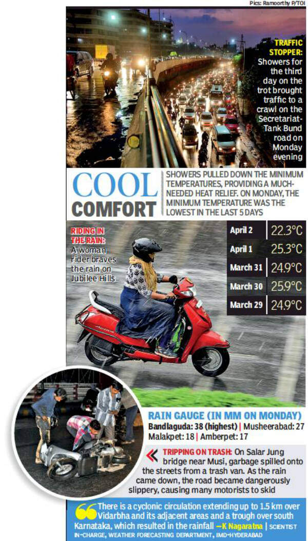
According to India Meteorological Department (IMD), the main reason for the rain on Monday was a trough extending up to south Karnataka. “There is a cyclonic circulation extending up to 1.5km over Vidarbha and its adjacent areas and a trough over south Karnataka, which resulted in the rainfall,” said K Nagaratna, scientist in-charge, weather forecasting department, IMD-Hyderabad.After the rainfall, though many people enjoyed the cool weather, those living in low-lying areas complained of water logging.
“The complete stretch in East Anand Bagh was water logged. The GHMC should press into service its staffers before the situation turns worse after monsoons arrive,” said Naveen M, a resident of East Anand Bagh.Rains also threw traffic out of gear in many parts of the city..
End of Article
FOLLOW US ON SOCIAL MEDIA


Hot Picks
TOP TRENDING
Trending Stories
In City
Entire Website
- UPS vs NPS Calculator: Is A Switch From National Pension Scheme to Unified Pension Scheme Really A No-Brainer? Check Calculations, Benefits - Top Points
- Top 10 sports stars turned power couples: From Agassi-Graf to Conner-Comaneci
- UPI transaction limit to change from September 16! Here are the new limits for various UPI payments
- Protests by Hindu groups in Shimla continue despite mosque demolition
- Schools to be closed tomorrow in these states: Here’s why
- 9 Inspirational Quotes Every Student Should Embrace for Academic Success
- 'We can be political rivals but ... ': BJP's reaction on minister's Rahul 'No. 1 terrorist' remark
- Donald Trump Jr dumps fiancee Kimberly Guilfoyle for Bettina Anderson?
- Trump vs Kamala polls latest: Harris gains from post-debate bounce
- NEET PG counselling schedule 2024 delayed: Why candidates moved to Supreme Court, hearing dates and other latest updates
- Jugraj stars as India beat China 1-0 to clinch record 5th ACT Hockey title
- Kejriwal resigns as Delhi CM; 'an emotional moment' says Atishi after staking claim to form govt
- Did doctors humiliate Mamata, or did she make it an ego issue?
- Kolkata top cop, 2 health officials replaced by Mamata govt
- 'No glorification of bulldozer justice': SC bans demolition till Oct 1
- In pics: How the nation marked PM Modi's 74th birthday
- Will Kejriwal pass the agni pariksha like Indira did in 1971?
- Reliance Jio confirms outage, here’s what the company said
- Who is Manoj Verma? Kolkata's new Police Commissioner
- Sukanya Samriddhi Yojana: What are the latest guidelines for SSY accounts? Check here

Popular Categories
Hot on the Web
Top Trends
Dominique PelicotUS Fed Rate CutIndia vs China Champions TrophyUPI Transaction LimitWhere to Watch India vs China Final Hockey MatchUPS vs NPS CalculatorKolkata Commissioner Manoj VermaNEET UG Admission CriteriaAtishiKolkata Doctor Rape CaseArvind Kejriwal Resignation LiveAli Khamenei TweetSuryakumar YadavVince McMahonTech LayoffsDonald TrumpLive Cricket Score
Trending Topics
Living and entertainment
Latest News
Pankaj Kapur is proud of son Shahid Kapoor’s film choices, calls him ‘the finest actor in the country’Mukhtar Ansari died of heart attack, not poisoning: UP's Banda district magistrate's report4 types of tea to improve gut health and ease digestive issuesMemeFi daily codes for 17 September 2024: Boost your earnings with daily codes and know how to maximizeKhatron Ke Khiladi 14: Shalin Bhanot hosts a fun party for his co-contestants Krishna Shroff, Abhishek Kumar, KaranVeer Mehra and othersDecoding how log analytics systems are enabling brands to derive maximum value from dataSebi U-turn: Pulls note blaming 'external elements' for staff stirAnother Mpox suspected case in India: Man showing symptoms admitted to hospitalTaurus, Daily Horoscope Today, September 17, 2024: Anxiety and stress diminishLiza Colon becomes 1st Latina to win Best Supporting Emmy AwardSelena Gomez recreates practiced applause she learnt from TV show Friends after losing at Emmys 2024Former WWE superstar is no longer listed on their internal rostersBeyond Paychecks: Job satisfaction, work-life balance more important than salary for Gen Z workforceThrowback: When Sunita Ahuja showered love on husband Govinda, 'A superb son, brother, and a very good father...'‘You is sleep or you can sleep’: Students prank Benglauru’s ‘pookie professor’ in viral videoWhy more couples aged 50 or older are getting divorcedThese are the most toxic fresh produce of 2024Things to do before, during and after Lunar Eclipse
Copyright © 2024 Bennett, Coleman & Co. Ltd. All rights reserved. For reprint rights: Times Syndication Service