Trending
This story is from September 28, 2023
In its highs and lows, 2023 springing weather surprises every month
Weather conditions in India this year have been erratic and extreme, indicating the impact of climate change. January was the coldest month in five years, while February and March were the hottest in decades. The monsoon season also experienced fluctuations, with a significant rainfall deficit in June followed by bumper rainfall in July. August was the driest month in decades, causing concern for the paddy crop. The irregularity in weather patterns is seen as a clear sign of climate change.

July brought bumper rainfall with a surplus of 75.4% for the month
Extreme weather events and related anomalous conditions are occurring as expected. But this year, the mercury and monsoon activities seem to have shown dramatic rises and falls, and the events followed too closely for comfort.
“The exceptional is becoming the new normal now.

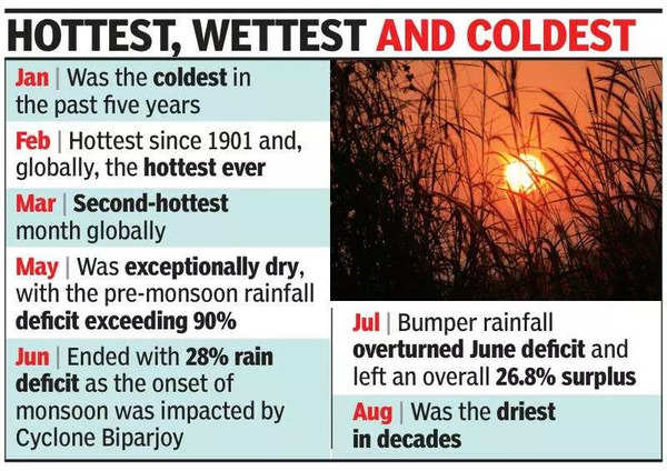
The nip in the air in January was unusually sharp, with the month ending as the coldest in the past five years. With the mercury soaring and persisting at above-normal levels for days, the last month of winter, February, followed by March, emerged as the hottest months for decades.
In India, February was the hottest since 1901 and, globally, the hottest ever in history. In March, the second-hottest month globally, summer began on an ominous note.
On March 1 itself, the India Meteorological Department (IMD), Panaji, recorded a maximum temperature of 37.2 degree celsius. No relief seemed in sight as the mercury remained stuck above 37 degree celsius for seven days and above 36 degree celsius for 10 days overall. It even soared to 38.7 degree celsius and 38 degree celsius on March 5 and 7.
“Historically, Goa has witnessed a higher temperature rise as compared to the national average. In Goa, temperatures have risen by about one degree celsius since the beginning of the 20th century, compared to the national average of about 0.73 degree celsius,” said Chaturvedi.
After summer began prematurely, the season’s peak, especially May, was exceptionally dry. “Each month sprang a surprise and left an indelible mark on Goa’s weather and climate. The mercury rise encroached on the winter in February. Higher temperatures in this month and March mimicked heat wave conditions. If the humidity was not low, the discomfort levels would have been higher,” said M R Ramesh Kumar, chief scientist (retired), NIO, and meteorologist.
At one stage, the pre-monsoon rainfall deficit even exceeded 90%. In June, conditions improved slightly. The monsoon onset on June 11 coincided with the formation of Cyclone Biparjoy. “Initially, the cyclone weakened the monsoon conditions. Overall, Goa received a mere 27% rainfall in just over three weeks in June,” said Kumar.
But July brought bumper rainfall. With a surplus of 75.4% for the month, the copious rain overturned the 28% deficit of June and left an overall 26.8% surplus that lasted during the driest August in decades.
With monsoon activity slackening after July 27 and in August, hardly 100mm of rainfall was recorded in nearly three weeks, triggering concern about the impact of the dry conditions on Goa’s paddy crop.
But a sudden burst in rain activity on August 25 and 26 brought some relief, as 93mm was added to the total within 48 hours, sustaining the overall surplus. However, the month logged just 269.4mm, as compared to the normal value of 710mm, making it the driest in decades.
Slack monsoon activity continued for nearly three weeks in September as well, but a moderately good spell during the past few days has again brought some relief.
“If the bulk of the entire season’s rainfall is received in just a month, it will be hardly beneficial, besides causing flooding and havoc. The runoff will be higher, and groundwater will not be recharged. If pre-monsoon rain is poor next year, there could be water scarcity,” said Chaturvedi.

About the Author
Paul FernandesEnd of Article
FOLLOW US ON SOCIAL MEDIA


Photostories
Hot Picks
TOP TRENDING
Popular Categories
Hot on the Web
Top Trends
Hurricane MiltonRatan Tata NewsNew UPI Transaction LimitRatan Tata DiesPM ModiShantanu NaiduTom BradyStock Market TodayNarayana MurthyElection Results 2024Israel Hezbollah WarRahat Tata Inspiring QuotesManagement Colleges of IndiaTop Medical Colleges of IndiaTop Engineering Colleges of IndiaTop Pharmacy Colleges of IndiaLive Cricket Score
Trending Topics
Diwali WishesBigg Boss Tamil 8 Contestants ListBhool Bhulaiyaa 3 TrailerVettaiyan Twitter ReviewSanjay Leela BhansaliVettaiyan ReviewBigg Boss 18 House PhotoDevara CollectionBigg Boss 18Deepika PadukoneShraddha KapoorRatan Tata Passed AwayColdplayNational Film Awards 2024Swatantrya Veer SavarkarColdplay India tour 2025Watch NFL Live StreamDress To ImpressRatan Tata DeathWordle Answer
Living and entertainment
Latest News
Ratan Naval Tata: The inspiring journey of Padma Vibhushan laureate and golden-hearted business tycoonHow Chennai Night Race swerved past challenges to zoom toward a brighter motorsports futureJiiva's 'Black' censored U/A, the thriller drama to release on October 11TCS cancels Q2 earnings press conferenceSamantha Ruth Prabhu shares playtime with Chinmayi Sripaada's daughter, says 'It took her 4.5 seconds to disown her parents'Mohanlal remembers late TP Madhavan: ‘His love and affection were akin to that of a father towards me'Buy only from Sanatanis, says Akhara ParishadWho is Noel Tata? Meet Ratan Tata’s half-brother, who could be successor at Tata TrustsDiljit Dosanjh pays tribute to Ratan Tata during live show: "He lived a flawless life, always helped others"Chiranjeevi, Mahesh Babu, Jr NTR mourn the loss of Ratan Tata, calling him "giant of industry" and "beacon of humanity"How to make Ginger Turmeric Shots for seasonal changePadma Vibhushan industrialist Ratan Tata dies at 86Ratan Tata: The industry titan with a golden heartAtishi bungalow row: AAP says BJP has anti-women mindsetManifesting with the 10/10 Portal: Zodiac-based guide for 2024Why are the CEOs of most luxury brands stepping down?9 proven techniques for fastest weight lossICC Women's T20 World Cup: Harmanpreet Kaur, Smriti Mandhana, bowlers demolish Sri Lanka as India get NRR boost
Copyright © 2024 Bennett, Coleman & Co. Ltd. All rights reserved. For reprint rights: Times Syndication Service